Tuesday, January 16, 2018

April 29 2016 Chase Log

Summary
A messy day reminiscent of 2015, with a strong HP supercell riding along the 44 corridor. This day ended up being challenging due to the meh terrain and lack of straight roads east of 44, but marked my first tornado of the season. 

We started out of Norman in the early afternoon with storms going up along the dryline just west of the Wichitas. Moved down 44 as the main supercell of the day began to take shape near Saddle Mountain. Initially we were looking to stay east of Fletcher and let it come to us but with how quickly it's low-level circulation ticked up, we instead moved into position to look down the notch west of Fletcher on the east side of Lake Ellsworth. We got our first view of the storm as it was rotating like a top and rapidly turning HP at this point. It had a decently well defined RFD cut with a solid updraft base/visible rotation. This storm also displayed the most eerie green glow I've seen outside of the Elmer storm.ec990ed07414220061a9ccf00c7cdf67.jpg After encountering a confused local in an old VW bug, we hauled it back east through Fletcher and over 44 before cutting north again. Most features were not discernible from our vantage point until we got east of Cement on US 277 after popping out on Country Street 2730. The storm was pulling in inflow like crazy by this point and already had turned it into an almost as dark as night lighting situation. As a result, none of my photos of the ensuing multi-vortex tornado came out well as we closed in on Ninnekah (also partly due to my lack of a tripod in strong inflow winds). Andrew Lyons managed to grab the following photo in the distance of the tornado as it touched down.0fe256f6cb5f63476cafba02d9756011.jpg Shortly after watching it move back into the rain, we continued east on US 277. The storm's massive gust front was rapidly approaching and the tornado was completely shrouded by the time we reached the Ninnekah Truck Stop. At this point, we got slammed by high winds and heavy rain/small hail. We continued east/southeast into a worsening road grid due to the numerous creeks/streams that feed into the Canadian River to the east. We gave up the ghost near Dibbler and headed back to Highway 9 with the storm on our heels. We rode it out as it entered Norman near Riverwind Casino as it continued to choke itself off. 


Definitely not the spectacular first tornado of the season I had been hoping for after the initial frustrations of April, but a decent chase nonetheless, even with the crappy terrain and worse road options.


Chase Stats
Miles Driven: 141
Cost: $10
Tornadoes: 1
Hail: Pea (1/2")
Winds: ~60 mph (RFD)
x

April 26 2016 Chase Log

Summary

Arguably the biggest bust of the year for me and likely numerous others as well. This day loomed roughly a week beforehand, with the usual bullish shear and instability values being spat out by the GFS and to a lesser degree, the ECMWF. It had all the classic calling cards of an old-school Plains tornado outbreak. However the day of ended up being quite different, with red flags put forth by the NAM and mid-range ensembles essentially ruining the day. Chased a supercell from Elmer, OK to roughly Snyder before letting it go. The second storm we approached as it was crossing the Red River had a terribly flat, laminar base with precipitation spread through it. All in all, not the day I had been hoping for.
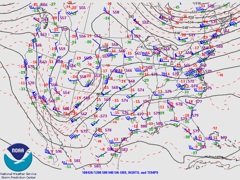

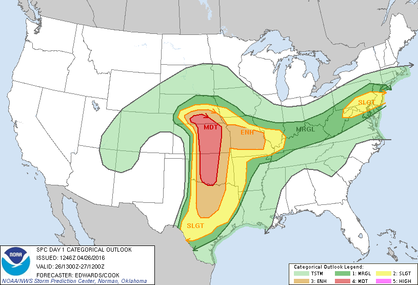
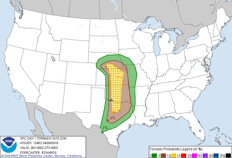

We left Norman around 1 PM CDT and initially moved for Lawton. The SPC threw out the now infamous PDS tornado watch as we were eating and shortly after we began to make our way down towards the Red River. By the time we reached Snyder, the first attempt at convective initiation was underway south of Crowell, TX. We moved west out of Manitou on OK5C and ended up sitting a few miles north of Elmer as the storm began to organize itself. We had a beautiful view over some open wheat fields to the south as the storm split, with the left split's base visible off to the southwest. 

0457a36eb30a93715ce8176a40fc5998.jpg

Shortly after we cut back east towards Tipton to stay ahead of any potential hail. After dipping south on OK5 out of Tipton, we stopped for a bit with some other friends to watch the storm take on a nice bell-shaped appearance. This storm also exhibited the first instance I can think of with gravity waves rippling through the anvil as the updraft grew.

56cba2196c5babe1323038f04546a5a2.jpg

2030ba0e2220199625e8a686ad283a63.jpg

eab398ae4eada672d01a906f618cff8a.jpg

About five minutes after the last picture, the storm finally managed to organize a wall cloud under a pretty hazy base. Only one attempt at a funnel ever seemed to get close as the storm rapidly became more and more HP due to seeding issues from the initial left split that had stuck around on its western flank.

b64608708629f62cc555fa1d04baff2e.jpg

We then took a somewhat ill-advised trip up dirt roads that paralleled US 183 to get a better view of the wall cloud. Thankfully we managed to make it back to OK5C west of Manitou to get a view of the now very HP storm where a lot of chasers had congregated. Our final view before leaving the storm to peek at a separate storm just across the Red River was a somewhat dramatic view of the RFD cut giving off a greenish-blue tint with the rear-flank gust front passing directly overhead.

432f40fdcde97a37c46966fe8d8e0482.jpg

14d8deb356916e0a51663aeb2ed2b917.jpg

The last storm of the day we saw ended up being a linear base with widespread precip falling through the middle of it. We were never able to catch back up with the initial storm but did get a decent lightning show on the way home. 

Chase Stats
Miles Driven: 341
Cost: $20
Tornadoes: 0
Hail: None
Winds: ~20 mph