Tuesday, November 11, 2014

Wrap Up: Chase Season 2014

In the face of the cold front that brought polar air from the Great White North last night, now is as good a time as any to go back and review chase season 2014. A season devoid of almost anything resembling a decent dryline day on the High Plains, the final chase ended up being my favorite.

March 15 2014 Central Texas
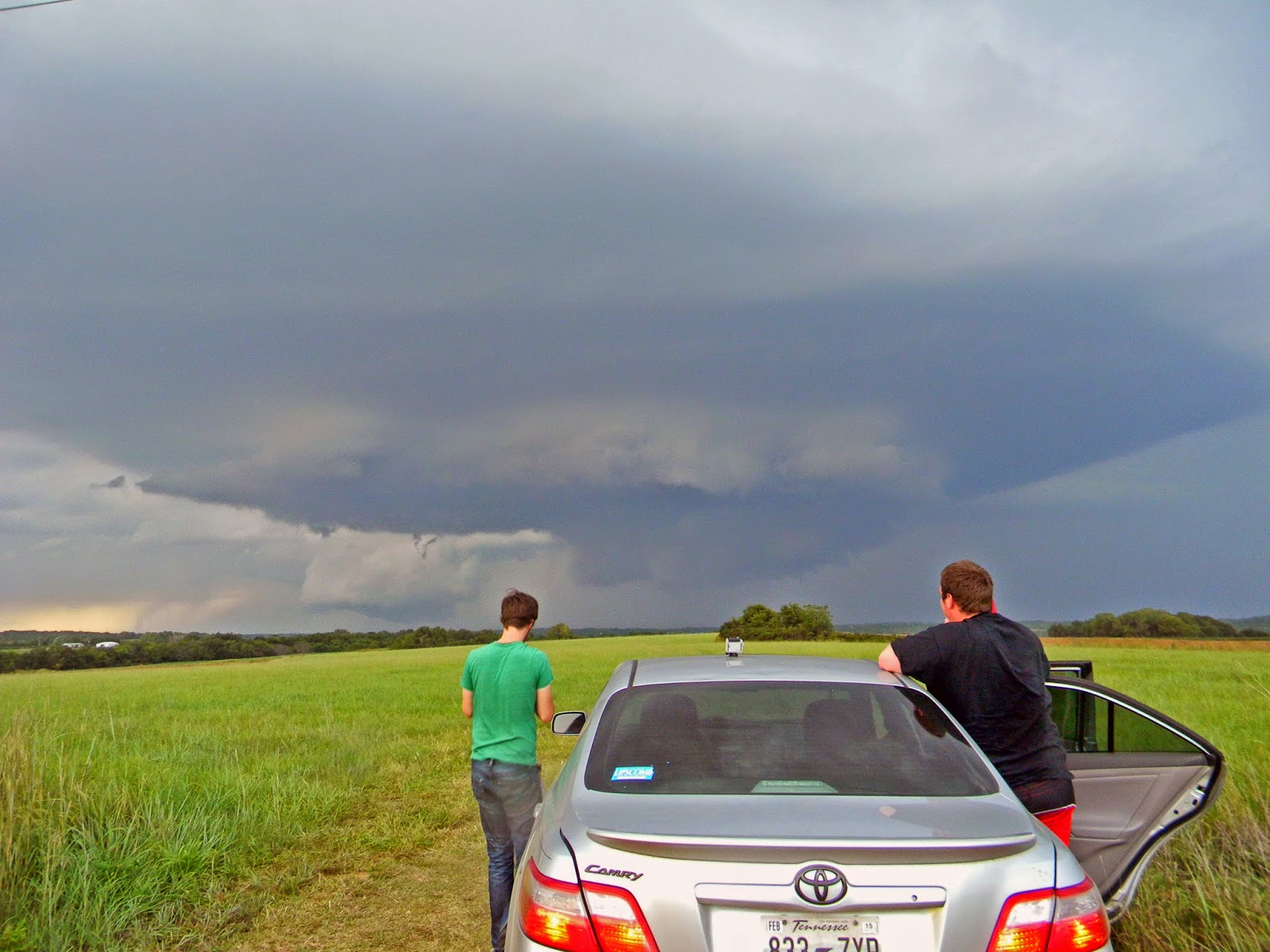
This day was easily the strangest chase day of the year for me. The synoptic setup was muddled, with a very weak shortwave impulse ejecting out of New Mexico the morning of and a very fuzzy dryline, with mid-50s to 60s spread from the 35 corridor to west past Abilene. The morning began socked in with thick nimbostratus as we departed Norman. After a data stop in Decatur we continued on to our target of Stephenville, Texas. A line of crapvection went up due west of us and appeared elevated and grungy. A few segments went severe warned but a second CU field was taking shape back on a sort of secondary dryline/moisture convergence zone under some decent upper-level diffluence west of Abilene. After assessing the options at the Starbucks in Comanche, SW of Stephenville (during which I nearly committed a felony against a defenseless laptop that refused to connect to wifi). After getting an outside opinion from Andrew, we decided to move west through the backroads of Texas Hill Country to make it towards the deepening Cu field. After snaking our way to just east of Abilene, we stopped in Baird for gas and continued south towards a storm taking a nice kidney bean shape that had erupted out of the Cu field just south of the first severe storm. We rapidly dropped south on US 283 and were treated to a weakly supercellular storm with some suspicious lowerings over the course of 30 minutes. We were the only chasers we saw on that road and it was dead quiet except for the occasional rustling of prairie grass from inflow and the rumble of thunder. The storm's FFD gradually pushed us south until it gusted out just north of Coleman and we let it pass. Afterwards we did some rainbow watching with Brandon Green, a panhandle chaser who I met for the first time followed by finding hailstones left behind. We ended the chase in Cisco at the Dairy Queen while watching the storm's pinkish updraft tower slowly slip into darkness before making the 6 hour drive back to Norman.


April 1 2014 Southern Oklahoma 
A bust of epic proportions on the first of what was progged to be a possible three day event across the Plains. Brady Kendrick and I planned to leave Norman after I got out of class while meeting up with Zack Allen at Brady's apartment. We rolled out of Norman relatively early with a tentative target of Waurika. Very decent H5 winds, around 75 knots were overspreading Oklahoma that morning per the 12Z analysis, but the horribly veered lower levels coupled with high sfc temps leading to rapidly dropping dewpoints doomed this day out of the gates. We planned on playing the triple point as the warm front drifted lazily north of the Red River, but modest overal forcing due to the trough being a few hours to far behind ruined this target's chances. TCu struggled all day as we patiently waited at a truck stop in Waurika, the cap turning out to be nigh unbreakable. After waiting for approximately two hours with towers repeatedly toppling over in the same spot, we decided to call it quits. A storm went up further down the dryline south of Throckmorton and briefly became surface based and spat out a few lowerings. We knew there was no way we could make it that far south so we called the chase , ate at the nearby Sonic and made our way leisurely back to Norman. It should have been a red flag for what the next day held. 


April 2 2014 North-Central Oklahoma
This day could have had it all. A juicy, very unstable airmass sat poised ahead of the dryline across west-central Oklahoma but failed to initiate anything of value. After debating the options, we rolled out of Norman around 5 to see if initiation would even take place thanks to the thermonuclear cap and no forcing. Storms never got going south of the warm front, with an LP supercell riding over the warm front up near Attica, KS. We sat outside Kingfisher hoping but nothing ever got close before the lack of forcing caught up to it. Such wasted potential. We would also end up not chasing the next day due to Andrew being sick and homework factors, meaning we missed the only tornadoes out of that trough. 


April 23 2014 Western Oklahoma & North Texas  
What a strange day this ended up being. Meager moisture with a lack of appreciable capping led to a convective mess of high-based storms across the eastern High Plains. Cj and I rolled out with an initial target of Sayre, before rapidly dropping south from Erick on Oklahoma 30, watching a nice high-based supercell along the state line east of Wellington, TX. The storm rapidly gusted out and became even more elevated as we traipsed east on Oklahoma 9 towards Mangum. We were in desperate need of gas by that time, and after running through three towns with no stations and meeting up with some people from OU, we came into Mangum with a decision to make. The storms to our north and west were in a soupy mess of elevated crap and there were two storms coming out of North Texas south of Vernon. We decided on the south option and went through Duke, cut to Altus and dropped south on US 283. We stopped and watched the western storm which appeared to actually be relatively lower than the other storms in retrospect, but abandoned it west of Electra for the eastern storm. We dropped south on TX 25 from Electra and ran into the most high-based POS of the year. It had to have had a base around ~2000-2500m. It did have a nice doughnut-hole shaped base with the updraft dead center with dancing rain bands in front of the setting sun. Not what we had been hoping for this day but it had to do. We let it go after about 25 minutes and rolled into Wichita Falls for dinner at McDonald's. The real treat ended up being the insane lightning barrage from the storms on our drive back up 44. It truly was amazing to watch despite the bust.


April 26 2014 Southwest Oklahoma  
Yet another bust. I had a "field trip" for my geography class to the Wichitas and after getting back at 2 PM rolled out of Norman going right back from whence I came. The moisture had initially started out in the low-60s, but as usual, it began to rapidly mix out and ended up sitting around the mid-50s. We rolled into Lawton around 3:30 and after sitting at a local park decided to go grab some food at BW3s. We anxiously watched the flat, lifeless Cu field to the WSW. Blips caught our attention but after waiting for another hour and a half, with nothing catching and the sun going down, we called it. Meager moisture and meh forcing ruined an ok shear environment. The story of 2014. 

May 21 2014 Central Indiana
A chase with the local gang on what had originally looked like a possible derecho day but ended up being a messy multicell clusterfuck. Aaron Rigsby, Nathan Curtis, Andrew Lyons and I left for central Indiana and sat on a farm road south of Rushville, IN for about two hours waiting on initiation. Storm erupted quickly and a severe warned storm slowly glided towards us. After waiting on it and seeing nothing good, we began to drift west to other storms with more promise. We managed to get a pretty cool shelf with some serious greenage back in the core but that was about it. We then weaved our way through a hellhole of forested hills just east of Martinsville before getting a glimpse of a massive shelf over the hills to our NE. After getting run over, we called the chase and headed home. 


July 27 2014 Eastern Ohio & Kentucky  
A moderate risk day in Appalachia suckers me in. Really strong shear but meh thermodynamic profiles and fast storm motions screwed us from the getgo. Initially unsure of where to target, went north to Wilmington, OH before hauling ass south to try and get in front of the supercellular rockets before they hit the actual mountains. Missed the 60 mph moving storm by 30 minutes and sat at a DQ in Fleminsburg, KY for most of the rest of the day split by storm just north of Wilmington, one of which eventually went tornado warned and the fast moving HP monsters too far to our south to catch before sunset. On our way back to Cincinnati, elected to not chase little storm that popped in far N KY just across the river from the city. That storm ended up producing some beefy lowerings in a state park to the east and a possible tornado. 2014 strikes again. 

September 1 2014 Southern Kansas  
Easily, and I mean not even close, the best chase day of the year for me. We were originally not planning on chasing this day after sitting out the crapfest the day before on an overhyped, moisture starved multicell-fest in Nebraska. It wasn't until after the 17Z sounding from Lamont came out that we seriously considered going north to Blackwell. An OFB was intersecting the WF just north of the Oklahoma state line between Blackwell and Wellington. Turning in the lowest levels looked great but a massive cap was also in place. After much debating, we hit the road out of Norman around 4:45 and made it to just south of the state line just as initiation was taking place. We decided to ignore the first hints of convection along the dryline to the west in favor of the much healthier TCu ahead of us just across the state line. After a failed attempt, the next one stayed. We made it across the state line and stopped south of Geuda Springs, KS to watch the prettiest supercell of the year for us. After watching the first RFD surge fail to spawn a tornado, we dropped back south and then east to Arkansas City. We made a serious mistake in going south and were forced to double-time back to a dirt road that was literally right on the state line. We watched the now mothership sup spin and occlude twice before attempting to go east but being forced back due to a wash out and shit road options in Osage county. We ended up missing the two tornadoes at dusk near Cedar Vale but that's just how it goes. We stopped briefly near Mullhall, OK to grab some crawlers before headed home. At least the season ended on a high note. 


Sunday, November 9, 2014

The Final Hurrah of 2014?

After a season fraught with horribly mixed-out moisture and troughs off in timing by about six hours, it looks like the 2014 chase season may finally be in it's death throes. After taking a dirty crap all over me the entire year, this bastardized excuse for a season may finally be over. A massive upper low spawned from the remnants of typhoon Nuri looks to swing into the Bering Strait tonight and open the gates for the Canadian cold air invasion. It's currently progged to swing through the Pacific NW and rapidly eject over the Dakotas, bringing an at least 30 degree change across the entirety of the Great Plains and Midwest. Add in the chance of snow going into the weekend, and it's looking like these two weeks of fall were just a little farewell before the arctic onslaught begins. I have never looked forward to the start of winter until now, with the hopes that a wet winter will maybe aid in reviving the almost dormant High Plains from the Panhandles up through to SW Nebraska for the 2015 season.


I was also sad to hear of Jim Leonard's passing  last week. I never had a personal interaction with or connection to him, but the loss of a pioneer who gave many chasers my age iconic videos (such as the Ft. Cobb tornado from May 3 '99) is profoundly saddening. May he rest in peace.


Wednesday, September 3, 2014

September 1 2014 Chase Log

I never thought I'd get a shot at a tornadic supercell once June closed out, but this past Monday actually saw a large, well structured supercell near Arkansas City, KS that I was able to chase! We ended up missing the two tornadoes that occurred just after sunset due to poor roads and an unwillingness to have to snake our way back into KS from Osage County, OK but even without the tubes this chase was a huge morale booster for what has been a shit season.

We didn't make the decision to chase until 4:15 and were out of Norman and our way for Blackwell to start. The sfc cyclone was sitting around Medford with a semi-sharp dryline and an OFB intersecting it just across the state line in KS. The 17Z sounding from Lamont was impressive, albeit with a large inversion at 700 mb. The wind profiles looked extremely favorable for at least supercells and with dewpoints kissing the lower-70s it began to seem as if LCLs wouldn't be too big of an issue. The SPC went with a SLGT across N OK with a 2% tor risk.


We watched on our way up as the first few attempts failed after going up on the northern side of boundary but by the time we hit Tonkawa full-blown CI was occurring. We decided against going after another storm that had just exploded farther west near Fairview on the dryline for the now strengthening supercell riding the OFB and undergoing a cell merger. As we closed in across the state line we got a view of the storm's base. From there, the chase only went up.


We were busting it east on US 166 and the storm was almost at a standstill making it easy to find a spot to get a good view of the storm's updraft base. We took a road that lead north towards Geuda Springs and sat for a good 15 minutes watching the best supercell that any of us had seen this season.


We noted rapid rising motion/lazy rotation on the right side and after reporting to SN watched the first RFD surge and occlusion. The lowering on the right got some decent spin going but alas nothing ever got close to touching. 


The storm had begun to drift ESE so we decided to hop back on US 166 and reposition. Unfortunately we became confused after driving through Arkansas City and then south and were forced onto a E/W dirt road on the state line. Regardless, we were in for a treat as the storm had just fully cycled for a third time and was on it's fourth occlusion. We sat and watched a great mothership for awhile before deciding to drop it (fail) due to its gusty, ragged appearance under the updraft.


After watching the storm spin harmlessly we decided to drop it initially and make a play at the storm that had shot off the dryline earlier. After realizing there was no way we were making that storm by dark (it was closing on 8:30) we stopped at a second severe storm to the west of the Arkansas City supercell. We watched a blood red sun drop beneath the updraft before the storm went completely cool and outflowy.


We made our way back to 35 and stopped at Braum's to grab some food where we learned of our mistake. A large elephant trunk had gone meandering SE near Cedar Vale, KS just before dark on the cycle immediately after we left the storm. Not the best way to end a chase, but it certainly didn't take anything away from the awesomeness we had seen before.

On our way back to Norman, we made a 10 minute stop to photograph lightning just east of Mulhall and got some great crawler action. A great chase day for this late in the season and an unexpected one at that. Here's hoping for more October greatness next month.


Chase Stats
Tornadoes: 0
Largest Hail: None
Highest Winds: 25 mph (inflow)
Miles Driven: 328.5
Cost: $27

Friday, June 20, 2014

A Strange Season to Behold

Sorry about the lack of updates, there's been little to talk about up until now. 2014 finally spat out the monsters everyone seems to have been searching for this season and let loose on eastern Nebraska the past several days. The Pilger twins followed by the Stanton wedge the next day and some big tornadoes in South Dakota the day after have made the season for many people. Unfortunately, Pilger was devastated as one of the multiple EF4s that the supercell produced tracked through the heart of town. A very sad event which could have been extraordinary if it had avoided towns completely. My thoughts are with the victims for the coming trials of attempting to rebuild and move on.

I don't hold much hope for being able to get anything great severe storms-wise during the remainder of my time at home but hopefully I'll be surprised by a stationary front with massive instability come early August. That or the fall season will have to come to my rescue, because I haven't seen anything worth much this season besides some elevated poop storms in one of my many forays into north Texas in and around Wichita Falls, an ok supercell between Cisco and Coleman, TX in mid-March and a mean shelf with some greenage. All in all, this is turning out to be a not so great year, despite my  multiple attempts in April to see something decent. The number of days that shallow moisture ruined is absolutely insane. I've chased SW OK/N Texas around from SPS to LAW four times this year and don't have jack to show for it. The Panhandle failed to do anything of note for the first half of the season which left me unable to get out to my favorite chase country of the Great Plains. Maybe October will be kind and come through for me a third year running. Only time will tell.

Saturday, May 17, 2014

Early Derecho Season?

It's May 17th, the Plains have been dead excluding May 10/11th and it looks like a derecho setup may already appear. The most recent 12/00Z runs of the GFS have been painting very compact NW flow across the Midwest with decently high instability and low-level moisture across IL/IN/OH. In short, it looks like we've skipped May here and gone straight into the derecho season that usually doesn't start until mid-June. I won't complain though, I'm eager to redeem the past two derecho day failures around here and hopefully next Wednesday provides.

Thursday, April 24, 2014

High-Based Hailers & State of the Chase Season Address

After weeks of futility I finally managed to wander into a severe thunderstorm. Yesterday provided some very nice high-based supercells in western Oklahoma/northwest Texas with quite the lightning show after dark. Cj and I left Norman for an initial target of Sayre with generally low expectations. While moisture return ended up being better than what had been progged, it appeared to be very shallow throughout the boundary layer. The other issue was the weak capping, leading to everything going up once instead of what should have been a widely-scattered structure day. After a brief stop in Sayre, convection initiated just off to our southwest near Wellington on the dryline. The storm grew pretty rapidly considering the modest thermodynamic environment and quickly went severe warned. We moved west to Erick before dropping south on OK 30. We initially were fooled by a scud bomb that had gone off right under the updraft base (the hope still finds a way out somehow), but after sitting and watching the storm for about 15 minutes we quickly ascertained that it had a base higher than the Rockies. We continued south, pausing to take in what had become a very pretty high-based supercell. The storm also had a pretty cool descending hail core just to the right of the updraft tower which made for some great views. Unfortunately my camera decided it didn't want to be of any use and I ended up with really crappy, light-washed images. We eventually continued down to OK 9 and headed east towards Vinson in a desperate search for gas (a Mustang does not get great gas mileage on state roads, who knew?). Although we didn't find gas until Mangum, we did run into two friends from OU and ended up caravaning with them for the rest of the day. We briefly stopped outside Reed to take some photos of the storm as it grunged out with more crapvection going up on all sides of it. during our gas stop in Mangum, we decided to abandon the storm for two coming out of north Texas that were 50 miles south of Vernon. We hauled it south out of Mangum to Duke and cut to Altus for the river crossing. Initially unsure of which storm to pick when we got across the river, we watched the western cell's base for a bit and became convinced the eastern storm had more to offer. In the end, either choice would have worked. Neither had much better structure than the other (although the western storm did have an interesting look to it as we left it behind). Regardless, the eastern storm was a beautiful sight with the sun setting just behind the FFD. 


State of the Chase Season
Well there's no way to really start this without saying one thing: this season has sucked. When I mean sucked, I mean it has been the worst chase season since David Hoadley started chasing way back during the early stages of the Cold War. The lack of not only tornadoes but supercells in general has been appalling. We're currently sitting at 64 tornado reports grand total for the months of March and April, with 11 in the "Traditional" Alley. My home state of Ohio has more tornadoes that Oklahoma currently and it's April 24th. While that will most certainly change this weekend, the trends have not been good. Just as every previous setup to date, the models have gone from singing high-praise to just absolutely shredding it. A mere 48 hours ago, the ECMWF and GFS were all-in on what looked to be a pretty spectacular severe weather event setting up across the central Great Plains. By today, the GFS has flip-flopped to the NAM's side with questionable moisture, capping and weak forcing for ascent all appearing along the dryline through southern Kansas into Oklahoma. It's starting to look like a distinct possibility that I will manage to not see a tornado in my brief time left on the Plains (exam week is coming in two weeks). My only hope if this weekend continues to trend down is the vaunted June period of the season back in the Midwest. While it's often ridiculed and ignored by the multitude of Plains chasers, I'd be surprised if an exodus east for some of the higher-end derecho days happened. Desperation can do some crazy things to people in this hobby. 

With any luck, Saturday/Sunday will eke out a decent tube somehwere in Oklahoma or Kansas, otherwise it looks like I'm destined to have a repeat of my horrible 2013 nightmare year. 

Thursday, April 3, 2014

This Week's System: Sir Busts A Lot

Wow what a crappy week for chasing this turned out to be. Brady, Zack Allen and I left Norman around two with an initial target of Waurika. Lack of appreciable forcing along the dryline/triple point doomed this day from the start. We sat at a truck stop in Waurika and watched as tower after tower shot upwards before toppling over and getting shredded. Many a healthy TCu was lost Tuesday. The only upside were the people I had a chance to meet in person for the first time, including Craig Maire, Chris Hayes, Mike Scantlin, Andrew Newcomb, and Evan Hatch as well as running into Blaize Edwards.  All that was salvaged was a little bit of dignity as we only had to make an hour and forty-five minute drive from Waurika back to Norman. The only supercell of the day ended up going just SW of Abilene, and went through the same area we had been two weeks earlier. It spat out some very nice structure and a few wall clouds near Throckmorton from what I've seen in terms of pictures so far. The bust itself wasn't so bad, but more what it portended for the next two days.


The next day would just end up rubbing more salt in the wound. A very moist, unstable airmass was situated squarely over all of western and central Oklahoma with the dryline slowly advancing out of the TX PH. A pretty stout cap was in place per the 12Z OUN sounding and most hi-res models had the only storms of the day breaking up along the warm front/triple point in the evening. The displaced dynamics for this day put out a red flag early, but it still looked like any storm that could maybe just get a whisper of life along the dryline in western OK would go crazy. Unfortunately, the only storms of the day ended up riding the north side of the warm front, with one of them having a nicely structured updraft and multiple gustnadoes before sunset. We were in no position to even get close to it and decided to call the chase around Kingfisher instead of continuing north any further. All attempts at TCu further west fizzled leaving us with a patchy cirrus deck and a juicy, untapped airmass. A lack of any trigger really killed the potential further south. Just goes to show how different a dryline day in April is compared to a dryline day in May.


Meanwhile in north Texas at Denton, there's a tornadic supercell about to cross I-35. 2014 not off to the best of starts.