Saturday, May 17, 2014
Early Derecho Season?
It's May 17th, the Plains have been dead excluding May 10/11th and it looks like a derecho setup may already appear. The most recent 12/00Z runs of the GFS have been painting very compact NW flow across the Midwest with decently high instability and low-level moisture across IL/IN/OH. In short, it looks like we've skipped May here and gone straight into the derecho season that usually doesn't start until mid-June. I won't complain though, I'm eager to redeem the past two derecho day failures around here and hopefully next Wednesday provides.

Thursday, April 24, 2014
High-Based Hailers & State of the Chase Season Address
After weeks of futility I finally managed to wander into a severe thunderstorm. Yesterday provided some very nice high-based supercells in western Oklahoma/northwest Texas with quite the lightning show after dark. Cj and I left Norman for an initial target of Sayre with generally low expectations. While moisture return ended up being better than what had been progged, it appeared to be very shallow throughout the boundary layer. The other issue was the weak capping, leading to everything going up once instead of what should have been a widely-scattered structure day. After a brief stop in Sayre, convection initiated just off to our southwest near Wellington on the dryline. The storm grew pretty rapidly considering the modest thermodynamic environment and quickly went severe warned. We moved west to Erick before dropping south on OK 30. We initially were fooled by a scud bomb that had gone off right under the updraft base (the hope still finds a way out somehow), but after sitting and watching the storm for about 15 minutes we quickly ascertained that it had a base higher than the Rockies. We continued south, pausing to take in what had become a very pretty high-based supercell. The storm also had a pretty cool descending hail core just to the right of the updraft tower which made for some great views. Unfortunately my camera decided it didn't want to be of any use and I ended up with really crappy, light-washed images. We eventually continued down to OK 9 and headed east towards Vinson in a desperate search for gas (a Mustang does not get great gas mileage on state roads, who knew?). Although we didn't find gas until Mangum, we did run into two friends from OU and ended up caravaning with them for the rest of the day. We briefly stopped outside Reed to take some photos of the storm as it grunged out with more crapvection going up on all sides of it. during our gas stop in Mangum, we decided to abandon the storm for two coming out of north Texas that were 50 miles south of Vernon. We hauled it south out of Mangum to Duke and cut to Altus for the river crossing. Initially unsure of which storm to pick when we got across the river, we watched the western cell's base for a bit and became convinced the eastern storm had more to offer. In the end, either choice would have worked. Neither had much better structure than the other (although the western storm did have an interesting look to it as we left it behind). Regardless, the eastern storm was a beautiful sight with the sun setting just behind the FFD.


State of the Chase Season
Well there's no way to really start this without saying one thing: this season has sucked. When I mean sucked, I mean it has been the worst chase season since David Hoadley started chasing way back during the early stages of the Cold War. The lack of not only tornadoes but supercells in general has been appalling. We're currently sitting at 64 tornado reports grand total for the months of March and April, with 11 in the "Traditional" Alley. My home state of Ohio has more tornadoes that Oklahoma currently and it's April 24th. While that will most certainly change this weekend, the trends have not been good. Just as every previous setup to date, the models have gone from singing high-praise to just absolutely shredding it. A mere 48 hours ago, the ECMWF and GFS were all-in on what looked to be a pretty spectacular severe weather event setting up across the central Great Plains. By today, the GFS has flip-flopped to the NAM's side with questionable moisture, capping and weak forcing for ascent all appearing along the dryline through southern Kansas into Oklahoma. It's starting to look like a distinct possibility that I will manage to not see a tornado in my brief time left on the Plains (exam week is coming in two weeks). My only hope if this weekend continues to trend down is the vaunted June period of the season back in the Midwest. While it's often ridiculed and ignored by the multitude of Plains chasers, I'd be surprised if an exodus east for some of the higher-end derecho days happened. Desperation can do some crazy things to people in this hobby.
With any luck, Saturday/Sunday will eke out a decent tube somehwere in Oklahoma or Kansas, otherwise it looks like I'm destined to have a repeat of my horrible 2013 nightmare year.
Thursday, April 3, 2014
This Week's System: Sir Busts A Lot
Wow what a crappy week for chasing this turned out to be. Brady, Zack Allen and I left Norman around two with an initial target of Waurika. Lack of appreciable forcing along the dryline/triple point doomed this day from the start. We sat at a truck stop in Waurika and watched as tower after tower shot upwards before toppling over and getting shredded. Many a healthy TCu was lost Tuesday. The only upside were the people I had a chance to meet in person for the first time, including Craig Maire, Chris Hayes, Mike Scantlin, Andrew Newcomb, and Evan Hatch as well as running into Blaize Edwards. All that was salvaged was a little bit of dignity as we only had to make an hour and forty-five minute drive from Waurika back to Norman. The only supercell of the day ended up going just SW of Abilene, and went through the same area we had been two weeks earlier. It spat out some very nice structure and a few wall clouds near Throckmorton from what I've seen in terms of pictures so far. The bust itself wasn't so bad, but more what it portended for the next two days.


The next day would just end up rubbing more salt in the wound. A very moist, unstable airmass was situated squarely over all of western and central Oklahoma with the dryline slowly advancing out of the TX PH. A pretty stout cap was in place per the 12Z OUN sounding and most hi-res models had the only storms of the day breaking up along the warm front/triple point in the evening. The displaced dynamics for this day put out a red flag early, but it still looked like any storm that could maybe just get a whisper of life along the dryline in western OK would go crazy. Unfortunately, the only storms of the day ended up riding the north side of the warm front, with one of them having a nicely structured updraft and multiple gustnadoes before sunset. We were in no position to even get close to it and decided to call the chase around Kingfisher instead of continuing north any further. All attempts at TCu further west fizzled leaving us with a patchy cirrus deck and a juicy, untapped airmass. A lack of any trigger really killed the potential further south. Just goes to show how different a dryline day in April is compared to a dryline day in May.


Meanwhile in north Texas at Denton, there's a tornadic supercell about to cross I-35. 2014 not off to the best of starts.
The next day would just end up rubbing more salt in the wound. A very moist, unstable airmass was situated squarely over all of western and central Oklahoma with the dryline slowly advancing out of the TX PH. A pretty stout cap was in place per the 12Z OUN sounding and most hi-res models had the only storms of the day breaking up along the warm front/triple point in the evening. The displaced dynamics for this day put out a red flag early, but it still looked like any storm that could maybe just get a whisper of life along the dryline in western OK would go crazy. Unfortunately, the only storms of the day ended up riding the north side of the warm front, with one of them having a nicely structured updraft and multiple gustnadoes before sunset. We were in no position to even get close to it and decided to call the chase around Kingfisher instead of continuing north any further. All attempts at TCu further west fizzled leaving us with a patchy cirrus deck and a juicy, untapped airmass. A lack of any trigger really killed the potential further south. Just goes to show how different a dryline day in April is compared to a dryline day in May.
Meanwhile in north Texas at Denton, there's a tornadic supercell about to cross I-35. 2014 not off to the best of starts.
Wednesday, March 26, 2014
Decent Precipitation Chances Today
For what feels like the first time in a very long time, SW OK/SE TX PH have a chance to pick up a decent amount of measurable rainfall. A decent amount of precip is moving through NW TX/E PH with smaller showers out ahead in W OK/SW OK. A few days of this could go a long way.

Tuesday, March 25, 2014
March 15 2014 Chase Log
Summary
A confusing synoptic setup gives way to a great first chase of the season. Chased with Cj Sayre, Tyler Snider, and Ben Davis into the Hill Country of Texas southeast of Abilene and managed to capture the best storm of the day after abandoning crapvection further east near our initial target of Comanche. Also got a chance to meet one of the panhandle guys, Brandon Green.
This day began showing up way out into GFS fantasy land and was bounced around anywhere from Friday to the next Tuesday. After a winter of a horrible flow regime, with stout east coast troughing leading to frequent polar intrusions, I was itching to get back out. Finally, the day got within mid-range model guidance and an interesting scenario took hold. A somewhat diffuse dryline was progged to set up just east of the Hill Country along US 281 and drift east during the early evening with possible supercellular storms firing as it neared the 35 corridor. Thankfully the setup looked assured to land on Saturday the 15th which was the first day of my spring break.
The morning of, a broad positively-tiled trough was sitting squarely over AZ/NM and looked to move east rapidly through the day. A weakness at the 500 mb level was a contributing factor to the uncertainty going into this setup as well as veered 850s and weak low-level flow.

Vissat also showed a very thick layer of stratus across much of the warm sector due to the rapid moisture return the morning of, throwing the decency of the thermodynamic environment into doubt.


The morning sounding from DFW did nothing to dispel our uneasiness with an elevated inversion and a veered low-level wind profile which did not bode well for our initial target of Stephenville 70 miles SW of Fort Worth. The SPC went with a SLGT over much of eastern Texas and a surprising 5% tornado risk for most of the SLGT. We rolled out of Norman around 7:30 and began to make our way south.


As we made our way down 35, we decided to completely avoid the construction hellhole that is Denton and continued SW towards Decatur from Gainesville on a TX highway. We were still socked in with heavy cloud cover and occasional drizzle at this point. We decided to make a stop at the McDonald's in Decatur to mooch off the free wifi and take a look at what had occurred over the past three hours since we had left. Sfc winds had continued to back out of the SE but were still extraordinarily weak and cloud cover was still persisting across much of the target area. We moved out of Decatur after an hour of sitting on our butts and made it to Stephenville around 17Z (noon) as the initial line of crappy storms went up along a moisture gradient/diffluence zone.

We stopped in the Starbucks to assess our options as storms were firing up and down the entire line. We also noted CU field way back S of Lubbock that was drifting east. After nearly smashing my computer in full view of innocent bystanders as it failed to connect to Starbucks' wifi, I called my friend Andrew and had him give me an update. The storms immediately in front of us looked like junk and the CU field to the west looked deeper and healthier. It also would be moving into an untapped environment for the next few hours. We were initially confused by the position of the dryline as the sfc obs didn't show a distinct boundary until about 40 minutes later.
After pondering our options and lots of encouragement from Andrew (I owe him a cookie), we decided to cut through the line of shit storms and go west. The next half of the chase was all Cj, he managed to get us through the spider web of backroads to I-20 around Cisco. On our way there we had the great pleasure of sitting behind this thing for roughly 15 minutes on a stretch of road where we hit about 3 towns.

We managed to get around this thing after several rage-filled attempts and continued on our way. One storm had already gone up just west of Abilene and managed to sustain itself. More storms looked immediately imminent out of that CU field.


We managed to get to Baird and gas up, before meeting with another friend from OU, just as the storm of the day got it's shit together to our immediate west. The storm quickly got it's act together to our SW as we leisurely dropped south on US 283.

The storm was crawling and we got a nice long stop just south of the county line on 283. At this point, we were all alone. Not a single chasers was on the road and it was completely silent except for the occasional grumble of thunder and wind being drawn in. The storm had a pretty rotund looking base even from a distance and a rather suspicious lowering.


We sat in this position for the next 20 minutes as the storm cycled through multiple lowering.


It finally got one really solid lowering going and had some pretty noticeable rising motion. It briefly spat out a lazily rotating funnel that none of us could confirm any ground contact on. The storm was doing great and still had a good 50 miles of untapped moisture to play in.


The storm cycled through one more beefy lowering before we decided to get a move on as rain from the FFD was beginning to fall.


We continued south and briefly attempted to move west to get closer but decided against it as terrain worsened and road options became sketchy at best. The storm had a ragged, elongated wall cloud briefly before it began to tighten up.
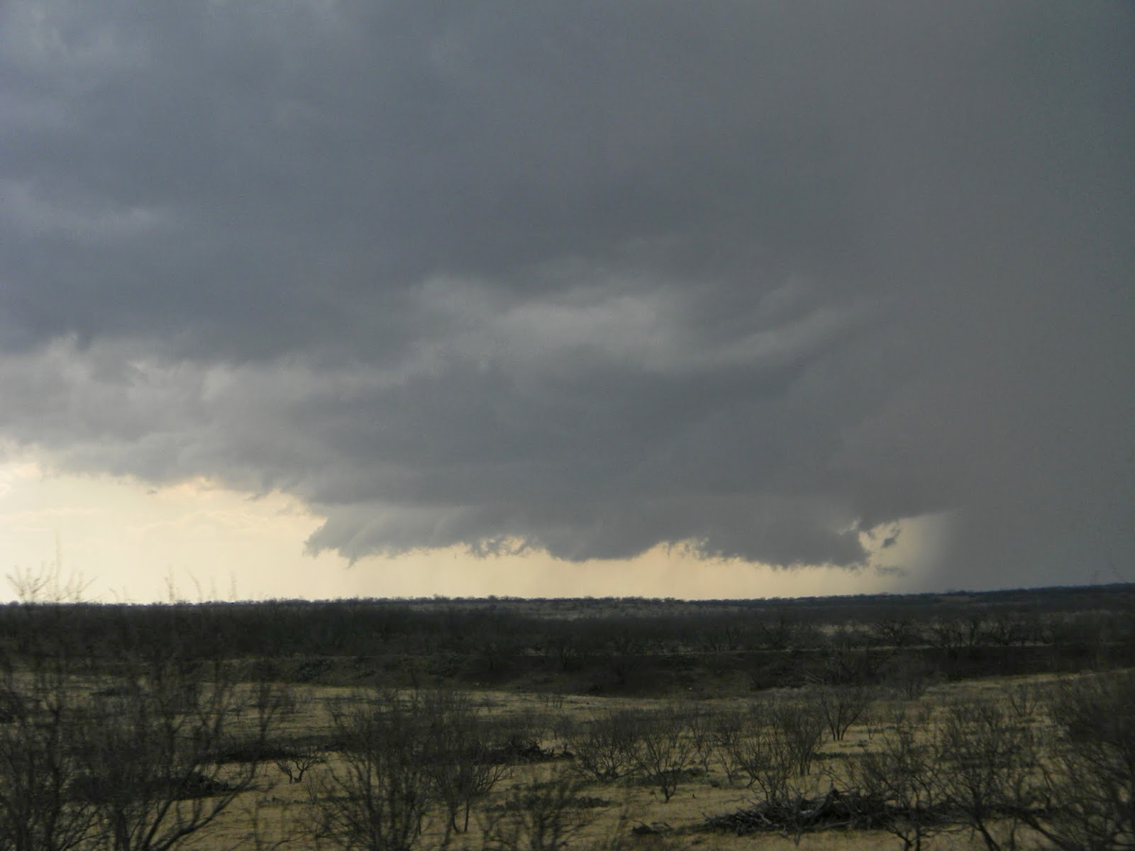
We stopped again about 12 miles north of Coleman to check out the storm and were treated to a great sight. The storm had a small little wall cloud towards the back with a turbulent updraft base and an inflow feature visible extending into the FFD.


Shortly after the last photo, we began to get rained on again and continued south towards Coleman. After one more brief stop that confirmed that the storm was gusting out, we decided to let it pass to our east before we went through Coleman and back northeast. The storm was still pretty in it's outflowy crapping of the bed.


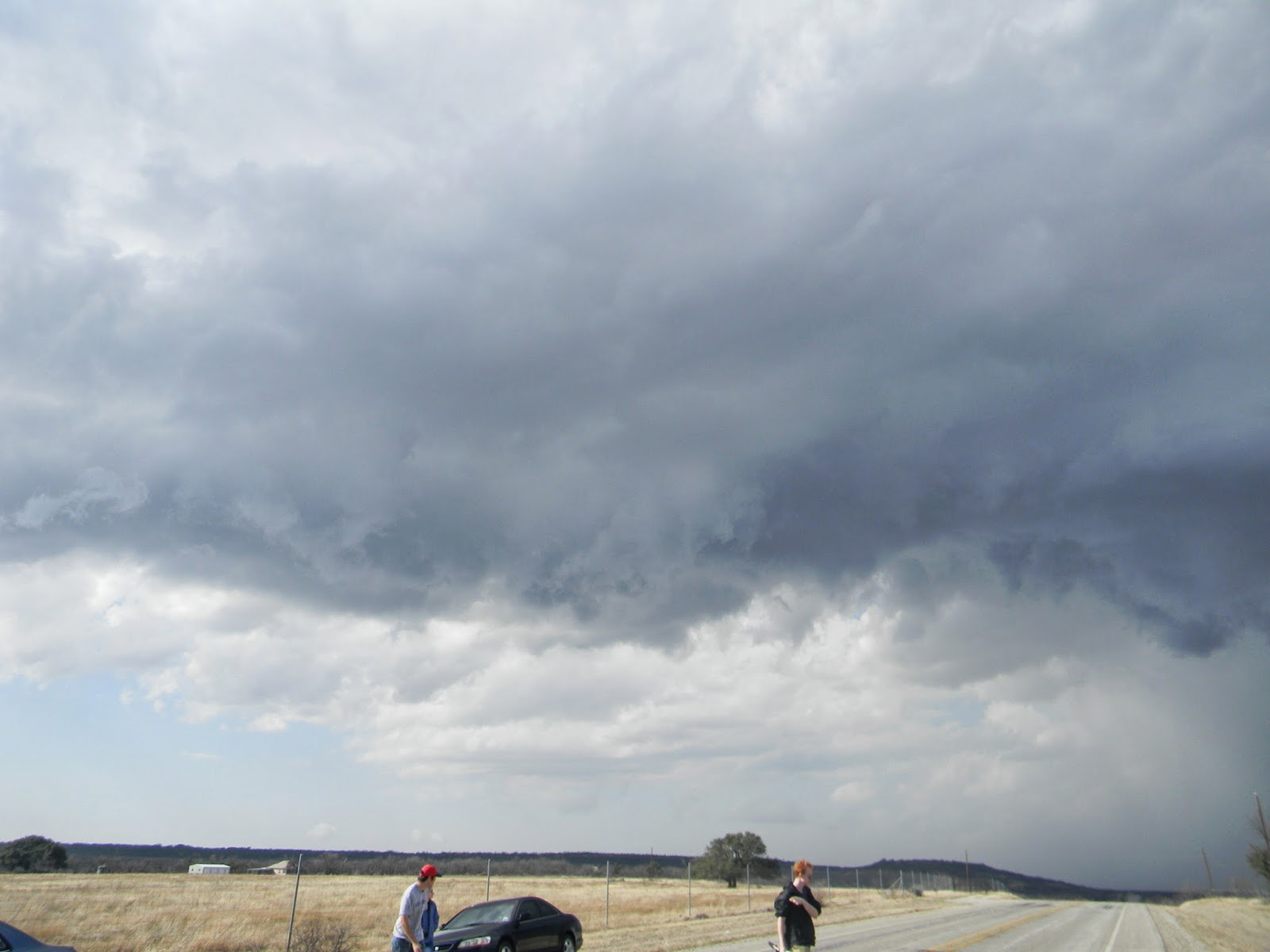


We let the storm slip east and then headed NE out of Coleman to watch the storm move away. It had a pretty looking updraft tower and even got a rainbow going at one point.


After sitting and watching it move away we continued east, while briefly stopping and checking out some the hailstones the storm had left behind. We managed to find a few golf balls mixed in (one had actually hit Tyler's trunk earlier during the second stop).


We continued north to Cisco and after grabbing a quick bite to eat at DQ, began the long trek back to Norman. Ben pointed out a fun fact on the way, that we were in fact closer to Mexico than we were Norman for most of the chase.
It was a great way to start the season and definitely has set the tone for me. Hopefully more of the same continues as we head into April. Check out below for the chase map and stats.
Side note: The Bigger Better Butter Jesus shirt seems to have good luck. His divine margarine is shining down upon me this season I guess.
Chase Stats
Miles Driven: 680.9
Cost: $32
Tornadoes: 0
Hail: 1 3/4" (golf ball)
Wind: 50 mph (estimated inflow)

A confusing synoptic setup gives way to a great first chase of the season. Chased with Cj Sayre, Tyler Snider, and Ben Davis into the Hill Country of Texas southeast of Abilene and managed to capture the best storm of the day after abandoning crapvection further east near our initial target of Comanche. Also got a chance to meet one of the panhandle guys, Brandon Green.
This day began showing up way out into GFS fantasy land and was bounced around anywhere from Friday to the next Tuesday. After a winter of a horrible flow regime, with stout east coast troughing leading to frequent polar intrusions, I was itching to get back out. Finally, the day got within mid-range model guidance and an interesting scenario took hold. A somewhat diffuse dryline was progged to set up just east of the Hill Country along US 281 and drift east during the early evening with possible supercellular storms firing as it neared the 35 corridor. Thankfully the setup looked assured to land on Saturday the 15th which was the first day of my spring break.
The morning of, a broad positively-tiled trough was sitting squarely over AZ/NM and looked to move east rapidly through the day. A weakness at the 500 mb level was a contributing factor to the uncertainty going into this setup as well as veered 850s and weak low-level flow.

Vissat also showed a very thick layer of stratus across much of the warm sector due to the rapid moisture return the morning of, throwing the decency of the thermodynamic environment into doubt.


The morning sounding from DFW did nothing to dispel our uneasiness with an elevated inversion and a veered low-level wind profile which did not bode well for our initial target of Stephenville 70 miles SW of Fort Worth. The SPC went with a SLGT over much of eastern Texas and a surprising 5% tornado risk for most of the SLGT. We rolled out of Norman around 7:30 and began to make our way south.
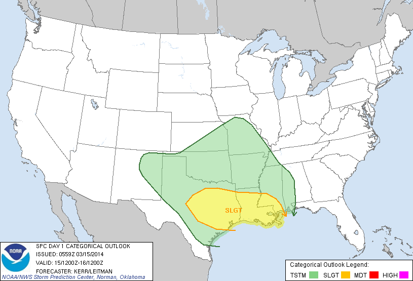
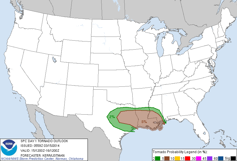
As we made our way down 35, we decided to completely avoid the construction hellhole that is Denton and continued SW towards Decatur from Gainesville on a TX highway. We were still socked in with heavy cloud cover and occasional drizzle at this point. We decided to make a stop at the McDonald's in Decatur to mooch off the free wifi and take a look at what had occurred over the past three hours since we had left. Sfc winds had continued to back out of the SE but were still extraordinarily weak and cloud cover was still persisting across much of the target area. We moved out of Decatur after an hour of sitting on our butts and made it to Stephenville around 17Z (noon) as the initial line of crappy storms went up along a moisture gradient/diffluence zone.

We stopped in the Starbucks to assess our options as storms were firing up and down the entire line. We also noted CU field way back S of Lubbock that was drifting east. After nearly smashing my computer in full view of innocent bystanders as it failed to connect to Starbucks' wifi, I called my friend Andrew and had him give me an update. The storms immediately in front of us looked like junk and the CU field to the west looked deeper and healthier. It also would be moving into an untapped environment for the next few hours. We were initially confused by the position of the dryline as the sfc obs didn't show a distinct boundary until about 40 minutes later.
After pondering our options and lots of encouragement from Andrew (I owe him a cookie), we decided to cut through the line of shit storms and go west. The next half of the chase was all Cj, he managed to get us through the spider web of backroads to I-20 around Cisco. On our way there we had the great pleasure of sitting behind this thing for roughly 15 minutes on a stretch of road where we hit about 3 towns.
We managed to get around this thing after several rage-filled attempts and continued on our way. One storm had already gone up just west of Abilene and managed to sustain itself. More storms looked immediately imminent out of that CU field.


We managed to get to Baird and gas up, before meeting with another friend from OU, just as the storm of the day got it's shit together to our immediate west. The storm quickly got it's act together to our SW as we leisurely dropped south on US 283.
The storm was crawling and we got a nice long stop just south of the county line on 283. At this point, we were all alone. Not a single chasers was on the road and it was completely silent except for the occasional grumble of thunder and wind being drawn in. The storm had a pretty rotund looking base even from a distance and a rather suspicious lowering.
We sat in this position for the next 20 minutes as the storm cycled through multiple lowering.
It finally got one really solid lowering going and had some pretty noticeable rising motion. It briefly spat out a lazily rotating funnel that none of us could confirm any ground contact on. The storm was doing great and still had a good 50 miles of untapped moisture to play in.
The storm cycled through one more beefy lowering before we decided to get a move on as rain from the FFD was beginning to fall.
We continued south and briefly attempted to move west to get closer but decided against it as terrain worsened and road options became sketchy at best. The storm had a ragged, elongated wall cloud briefly before it began to tighten up.
We stopped again about 12 miles north of Coleman to check out the storm and were treated to a great sight. The storm had a small little wall cloud towards the back with a turbulent updraft base and an inflow feature visible extending into the FFD.
Shortly after the last photo, we began to get rained on again and continued south towards Coleman. After one more brief stop that confirmed that the storm was gusting out, we decided to let it pass to our east before we went through Coleman and back northeast. The storm was still pretty in it's outflowy crapping of the bed.
We let the storm slip east and then headed NE out of Coleman to watch the storm move away. It had a pretty looking updraft tower and even got a rainbow going at one point.
After sitting and watching it move away we continued east, while briefly stopping and checking out some the hailstones the storm had left behind. We managed to find a few golf balls mixed in (one had actually hit Tyler's trunk earlier during the second stop).
We continued north to Cisco and after grabbing a quick bite to eat at DQ, began the long trek back to Norman. Ben pointed out a fun fact on the way, that we were in fact closer to Mexico than we were Norman for most of the chase.
It was a great way to start the season and definitely has set the tone for me. Hopefully more of the same continues as we head into April. Check out below for the chase map and stats.
Side note: The Bigger Better Butter Jesus shirt seems to have good luck. His divine margarine is shining down upon me this season I guess.
Chase Stats
Miles Driven: 680.9
Cost: $32
Tornadoes: 0
Hail: 1 3/4" (golf ball)
Wind: 50 mph (estimated inflow)
Subscribe to:
Posts (Atom)