Tuesday, November 1, 2016

June 4 2015 Chase Log

Summary

Simla day. One of the beastliest supercells of the season hovered across the eastern Colorado prairie while a large number of chasers including myself sat in northwestern Kansas, baking in sticky June heat on the High Plains. What had initially looked like a very promising day for some picturesque tornadic supercells in northern Kansas turned to pretty big disappointment as towers struggled to break through the cap in a primed environment. Colorado meanwhile put on another show of multiple tornadoes under a huge mothership of a classic supercell.


As most of my usual chase partners had departed the Plains for the summer or were otherwise disposed, my friend Mark and I went alone to the warm front draped across northern Kansas. After getting an early start, we managed to make Salina by noon before jaunting west to Russell and gassing up. The air was juicy, with the dewpoints climbing into the low 70s and a Cu field began to slowly fill in through the early afternoon. We continued north out of Russell to just east of Paradise at the junction of US 281 and KS 18. We ran into Ben Holcomb, and shot the breeze for roughly 2 hours as the Cu field slowly bubbled along. UCAR had launched a sounding in Phillipsburg and noted a strongly favorable atmosphere for supercells, with the cap still holding strong.

 Finally, a tower shot off out of a soupy mess of clouds around 2145Z (4:45 PM CDT).  We moved rapidly north towards Osborne to get in front of it.


However, it was not to be. The tower almost immediately was high based and slowly began to wither away from the base up and a mere 30 minutes after the above image, was nothing but an orphan anvil. We sat, frustrated, just outside of Osborne as the orphan anvil slowly drifted away and dissipated.


We threw in the towel around 5:30 and began to drift back east towards Glen Elder for an easy jaunt down US 81 to I35, but not before we were stopped by a sudden explosion of convection to the west near Quinter. We immediately turned around (running back into Ben in the process) and snaked our way through Stockton and Hill City and south into the heart of Trego County by way of WaKeeney. On the way down 70, we were treated to a crisp updraft.


Shortly after the photo above, we dropped south into the Smoky Hill River and it's chalky draws. The roads were predictable horrible (Trego County is notorious for being a chaser's nightmare with roads) but were able to pull off and view the somewhat benign storm in front of us. By this time, a nice liberty bell-shaped supercell was ongoing further to our northwest near Atwood but it was too late. We stopped on an isolated road and decided to enjoy what was becoming a great lightning show.


After enjoying a 30 minute lightning show, Mark and I decided to begin to trek back towards 70. We had strayed farther west than initially anticipated and were running low on gas. After gassing up in Quinter, we began the long drive back to Norman, with lightning trailing us the whole way. We arrived, nearly on death's doorstep, at 4AM. Unfortunately there wasn't a whole hell of a lot to show from this chase and the failure of the eastern target in comparison to what went down in Colorado made it a tough pill to swallow. This would be my only chase of June and helped continue my dislike for the month.

Chase Stats
Miles Driven: ~963
Cost: $34
Tornadoes: 0
Hail: None
Winds: None

Monday, September 5, 2016

May 16, 2015 Chase Log


Summary

The grandaddy of the 2015 season for me. Another day where heavy precipitation lopped off the northern target along the dryline, with the southern end of the target becoming southwest Oklahoma along the river. After setting up shop in Childress, noted that storms were generally elevated and we continued to wait on a storm to establish itself. Shortly after repositioning to the east of town, two cells congealed near Paducah and began to work their way northeast. Eventually, the storm became supercellular as it neared US 287 before producing a large wedge tornado southwest of Elmer, OK near the US 283 Red River crossing. The tornado lasted for some time and we managed to keep a decent distance, but not enough to avoid losing the windshield to inflow-driven baseballs. The storm rapidly went HP throughout the tornado's life cycle and we eventually dropped the storm and finished with wings in Lawton.


This day popped up on the radar roughly three days in advance, with generally poor consistency between the models. The NAM continued the trend of under-forecasting shear with the GFS (somewhat correctly) shooting low on progged CAPE values in the warm sector. The general consensus was that morning precip would likely be a problem regardless of the model solution and it would come to fruition that morning, as elevated storms and clouds socked in the northern end of the target area. This effectively removed a western Kansas target that had been tossed around for the likely better shear that would be present because of proximity to the main impulse.

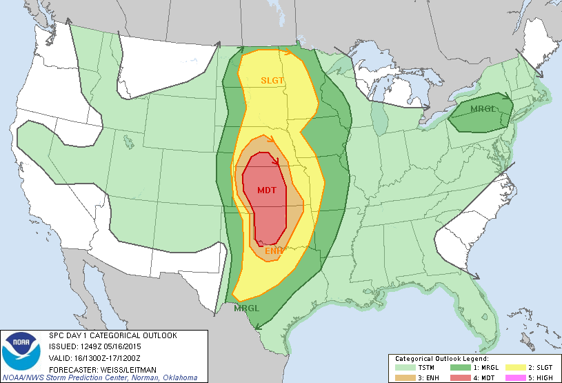
However, the SPC maintained a large moderate across the southern Plains, with a large 15% hatched tornado risk present on the 13Z outlook.


This would be amended in later outlooks to essentially encompass western Oklahoma but it was clear that the possibility for several tornadoes was there. As we rolled out of Norman, we decided on an initial target of Cordell. We arrived in Cordell shortly after 11 but decided to continue trekking further south as it became apparent the better clearing was shaping up along the Red River. As we entered Hollis, storms began to fire in the Texas Panhandle. The initial storms looked extremely messy and we decided against moving on the storm near Wellington which would produce a rain-wrapped tornado that some chasers managed to peek through the rain at.


The storms in and around Childress continued to look anemic and we pondered our options. Storms were beginning to fire to our south/southwest near Paducah and we had few other options at the time so we began to drift east towards Quanah. We mucked about on dirt roads south of Quanah as the storm rapidly got it's act together and became severe warned at roughly 2140Z. We booked it east to Chillicothe before turning north on a series of farm market roads and got our first solid view of the storm's base, which was beefing up as dusty inflow came howling in.


We continue northeast towards US 283 to get to our river crossing and hopefully beat the storm. 20 minutes after the photo above, the storm went tornado warning with a tight low-level circulation as it crossed over the Red River. Our view of the base was obscured by the RFD as we crossed the river.


The tornado was ongoing as we crossed the river, and made a slight jaunt back into Texas, before moving south of Elmer. With a hazy view behind us, we didn't get the full view until the tornado was roughly 1.5-2 miles off and were surprised when the barrel-shaped funnel emerged.


We stopped briefly outside a farm house north of Elmer as the tornado closed in on US 283 before quickly bailing north towards our east option (OK-5). On the way, we encountered extremely strong inflow accompanied by wind-driven hail up to the size of baseballs. The windshield did not survive after a baseball scooted across the hood and hit the bottom right corner, with cracks spider-webbing to the top. We hauled it on OK-5 and stopped to view the wedge back to our southwest.


We continued east and decided to stop outside Tipton and ran into a few friends. We watched as the tornado transitioned into a stovepipe, partially concealed by rain as the supercell became more HP.


After the photo above, we continued through Tipton as the conga line of chasers snaked their way down OK-5. We never felt comfortable enough to try and hop back in front of the updraft region of the storm as the storm began to approach the Wichita Mountains. After pushing through Snyder, we cut east towards Cache in search of gas out of the way of the supercell. We briefly stopped in Cache which allowed me to grab the last photo below of the twisting updraft tower to the north.


We decided to call the chase at the gas station as the windshield was becoming unstable and scurried into Lawton to the BW3s before the rain arrived. The tornado drought that had been ongoing since 2013 finally ended.

Chase Stats
Miles Driven: 451.4
Cost: $32
Tornadoes: 1
Hail: 2.75"
Wind: 65 mph

Saturday, July 23, 2016

Summer Under the Heat Dome

So far, this July has been par for the course in Oklahoma. We're still sitting under the same high pressure dome that's been plaguing the S. Plains for the past month or so, with mid-90s highs and 70F+ dewpoints. Norman is currently sitting at an enjoyable 92/71 as of 12:05 with not a cloud in the sky. Not a whole lot looks like it'll be changing with the upper air pattern through the end of the month and into the first week of August but the hope for another good fall season is about all that's left at this point.

I'm slowly plugging through charts and getting my last three chase logs for 2015 prepared before I begin digging into 2016. Blessedly, none of this season's chase days should take a long time to write, due to the short nature of most of the chases I had this year outside of May 24th and April 11th. Be on the lookout!

Friday, June 17, 2016

A June to Forget

After the swashbuckling few weeks of May that spat out the best tornadoes of the season, it seems June isn't likely to follow with it's own show. June 11, June 13 and June 14 all produced good tornadoes on the Plains, most notable was probably June 13, which saw a decently structured cone from Trinidad, CO to the Black Mesa of Oklahoma (OK's highest point) and then followed up with a large tornadic supercell north of Amarillo and south of Morse which spat out one solid tornado before congealing in the Canadian River Valley. But, the paucity of consistent setups is what's putting this June up there as a tough one. The death ridge currently sitting over us has been allowing massive amounts of moisture from the GOM to flow northward (The Norman Mesonet site recorded 91/78, the second highest dewpoint temperature in it's history) but the strength of the high pressure dome currently over the Central and Southern Plains is forcing impulses well into Montana and beyond. It's looking unlikely that I'll be stepping out the door to go roam the Great Plains any time soon as it stands, and it may end up being autumn before I get the opportunity for one last round of chasing before winter sets in.

Friday, June 10, 2016

May 9 2015 Chase Log

Summary

A tricky moderate risk chase day to say the least. Initially thought Wichita Falls would be sufficient as a target but ended up getting hamstrung by not bolting for the Cisco storm early, which would produce a slow-moving EF3 stovepipe. We wound up picking the middle storm for unknown reasons near Graham, TX and watched easily the least impressive supercell of the day slowly kill itself as it traipsed east through god awful terrain.This day would become more noted for the absolutely stunning tornadoes that occurred on the High Plains of Colorado near Eads, with the middle ground in OK/KS getting rained out as was tradition for 2015.


This day was the first chase opportunity that presented itself after I had fully finished exams. I had missed the Bridge Creek and other assorted tornadoes on May 6th due to a GIS exam as the supercell marched through Central Oklahoma and was desperate to get out. As was par for the course, morning convection created a messy and complex forecast scenario. Initial thinking was that the eastern TX Panhandle might be in play, but the MCS shown above took it out almost immediately. After analyzing data, it became a fast moving OFB was moving south past the Red River and would be in a prime location to possibly produce a few tornadic supercells. A deep trough was digging into the Four Corners and began to eject as the day went on. Copious amounts of moisture pooling south of the OFB and along the dryline made the target easy. We set out with an initial starting point of Wichita Falls.

We arrived in Wichita Falls shortly after 20Z and looked over data. Convective initiation was already well under way further south past the I-20 corridor, well south of the advancing OFB. We struggled to make a decision due to uncertainties and a lack of solid analysis from certain persons and decided to stick it out further north and begin to drift towards Graham.


We first stopped north of Olney to assess as storms were rapidly going up along the dryline to our west. By this time, it had become apparent that the storm nearing Cisco would be producing in short order and we had no choice but to stick north as there was no way we were getting that far south in time.


We continued to drift south and eventually found ourselves north of Graham with a potential supercell beginning to take shape west of town. The storm initially looked good; with a large rounded base and solid updraft plume.


The storm had initially appeared healthy, but as its base drew closer, it became very apparent that it was struggling in the low levels. Ragged, unorganized rotation was evident, but never threatened to touch down. We had lucked out in finding a great spot to view it from, with hills on three sides except where the storm was coming from. Below was about the scariest it would look with a fakenado behind the cut.


We began to get forced back towards Graham as the storm continued ENE and began to note the unusually cold air pouring out of the storm. The outflow had to have been a full 25-30 degrees cooler than the ambient temperature. The features below exhibited almost no rotation as cold outflow continued to rush out of the storm.


After hustling back through Graham, we continued on US 380 east until we found a good overlook back towards Graham at some baseball fields southwest of Bryson. The storm did have an interesting look to it, but at best it was "kind of pretty". It's lowering was ragged and almost stationary to the naked eye. The storm began to rapidly elevate it's base.


Shortly after the last photo, we continued through Bryson before calling the chase and headed back to I-44. The storm completely collapsed and flattened out as we drove north, to the point where we ran into almost no precipitation on the way. After fuming for a few minutes in the backseat, it was eyes on the next round of setups coming exactly one week later.

Chase Stats
Miles Driven: 442.1
Cost: $40
Tornadoes: 0
Hail: None
Highest Winds: None

Thursday, May 19, 2016

May 9 2016 South-Central Oklahoma Tornadoes

It's been a very busy spring so far between storms, school and work. Finally, here are my pictures from the SC Oklahoma tornadoes near Wynnewood, Sulphur and Bromide. I'm continuing to chip away at last season's chase logs so I can begin on this season's chase logs before I get too behind. Photos will be captioned below.


First view of the Katie-Wynnewood EF4 north of Wynnewood as it churns west of I-35 


The tornado as it begins to enter it's ropeout phase crossing I-35. Sitting just east of Wynnewood. 

The tornado begins to come undone completely with a massive barrel updraft and long inflow tail

The condensation funnel rapidly evaporates

The large mothership looming south of Wynnewood prior to the Sulphur wedge


The large Sulphur wedge about 4 miles north of Sulphur. Inflow was quite strong.

The entire updraft and wedge 

Hard RFD cut with solid updraft tower and the low contrast wedge continuing to the east

The Bromide tornado shortly after touching down. Viewed from southeast of Hickory.


The tornado viewed from full zoom as it morphs into an elephant trunk


The ropeout stage begins

Displaying walled structure in the center 

Rapidly breaking down after 7-8 minutes on the ground 


A distant view to the north at the Norman LP 

Arguably one of, if not the best chase days I've had. We saw four tornadoes in all. The Katie-Wynnewood tornado was initially rated as an EF3 before being upgraded to EF4. Both the Sulphur wedge and Bromide tornado were rated EF3.  

Looking ahead, it looks like we have an active week of some less synoptically-evident severe setups starting Sunday on the High Plains. It should be a busy week so updates may be few and far between for the next 7-10 days.