It's finally that time of year. Central Oklahoma has begun to cool off drastically this past week with another cold front progged to come through later this week. I'm currently in the process of acquiring some new gear for next season, namely a decent camcorder and some Aquapel (for those of you using Rain-X, I'd recommend trying Aquapel) as well as refurbishing my tripod, which is, no pun intended, on its last legs.
In other news, only 102 days until the unofficial start of my chase season 2014. I'm still extremely far behind on most of my chase logs from the first half of the 2013 season and I likely won't finish until after exam week when I hit winter break. Until then though, I must content myself with the Bengals playoff chances and the possibility of OU making a bowl that doesn't have ".com" at the end.
Monday, November 18, 2013
Sunday, October 20, 2013
Wrap-Up Chase Season 2013
After arguably the most frustrating season I have ever had, the fat lady has finally sung for my 2013 chase season. I'll have a review of all the chase days below. I also will be adding my remaining three chase logs in the next week or so, including the October 4th supercell near Clinton, OK. Below is a general overview of all the chase days this season.
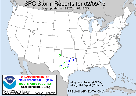
February 9 2013 Texas Panhandle
A very marginal day that appeared on the models and looked too good to be true for the eastern panhandle. I ended up chasing with Zach Elliot, Jon Stone and Brady Kendrick. After photographing an awesome abandoned gas station in Hollis, we went and hung around the Mempis, TX area until sunset. Storms never did fire in the daytime, but the dryline kicked up a dust storm in its wake along I-27. After grabbing dinner in Memphis, storms exploded about 30 minutes after sunset. We hopped northwest on US 287 and southeast of Clarendon caught the severe storms that had started lining out. After Brady's car took a few tennis balls we bailed back east and south to get out of the way (hitting a tumbleweed of doom on a market road). Unfortunately I never had enough time to get my camera out to get a photo of one of the hailstones. This day definitely set the marker for 2013.


March 9 2013 Southern Oklahoma & Northern Texas
A very under-performing day. Instability in northern Texas was never quite realized due to thick stratus until roughly 19Z across northern Texas and southern Oklahoma. I chased with Jon Stone and ended up heading out of Norman in the early afternoon. We caught the first severe storm of the day east of Duncan and got probably the only storm of the day that came close to realizing any of the potential of the shear environment. The storm displayed some slightly supercellular characteristics with a lowering that had visible rising motion from a good distance away before lining out and dying as it went back up into Norman. From that point we continued south and entered Texas around 21Z and got to a stopping point in time to see a pretty cool multi-tiered shelf outside Gainesville. We then continued dropping south and ended the day watching some junk storms near Era before heading back to Norman.


April 7 2013 Western Kansas
One of my favorite days of the season. Chased with Brady Kendrick and Zach Elliot in western Kansas on a decent day across Kansas. We set out from Norman around 18Z with the original target of Alva, OK. We were expecting more discrete, supercellular storms along the KS/OK state line in the early evening but that never materialized due to cloud cover over much of NW OK limiting the thermodynamic environment. The only supercell that day formed along and rode the warm front way up near Great Bend, KS. We initially had given up on the day around 23Z as turkey towers were toppling all over SW KS and were halfway to Greensburg (I hadn't seen the town's recovery) before turning back around and blasting north out of Pratt after seeing a nuclear updraft to our north on that WF supercell. While we failed to catch it when it was at its most picturesque, we were still able to get some excellent shots as it neared sunset southwest of Great Bend.


April 17 2013 Southwest Oklahoma
This day has a special place on my s**tlist of chase days. It's arguably the most underwhelming day I have ever had the displeasure of wasting gas money on. This day had been progged by the GFS and to a lesser degree, the Euro, to be the first legitimate tornado day of the 2013 season. That is until, the NAM got involved. The crashing cold front solution and weak H7s it predicted would end up coming true and cutting this day down like the Reds' playoff contention. Andrew Lyons and I ended up chasing with a group of meteorology friends from OU and reached the first supercells east of Lawton around 19Z. We sat back and watched the first supercell go by and spit out a lot of wind and rain. We then side-stepped it and went after the next supercell. South of Lawton that storm quickly died. At that point we were sitting on a small country road south of Lawton watching this day crash and burn. That is until one HP supercell decided to tick up its inflow (which was some of the strongest I have ever been in) and spin out a brief bird fart in Lawton. We had a very murky view and except for the first powerflash which gave us a brief glimpse, we never saw anything else. After our crappy encounter of the spinny kind we debated whether or not to sit and wait on more storms coming up. Those storms would end up biting it as they entered a worked-over environment with crappy mid-level winds. We then decided against moving south to tail-end charlie near Vernon, TX (which would produce the only decent-ish tornado of the day) and headed back to Norman on the heels of the crappiest excuse for supercells of this season.


May 18-31 2013
I was on a family vacation to the west (Grand Canyon, Bryce Canyon, Vegas, etc.). A little bit of me died.
July 12 2013 Eastern Iowa
A very disappointing bust day with Andrew Lyons, Nate Curtis and Aaron Rigsby. We initially saw some potential in eastern Iowa with the target set as Iowa City, but by midday it became readily apparent that nothing was going to happen. We stopped in central Illinois, turned around and drown our sorrows in Sweet Tarts with little unicell crappers shooting off all over creation.
September 27 2013 Texas Panhandle
Another marginal fall chase day that ended up being ok. I chased with Brady Kendrick with the initial target set for Groom. We got to Groom just as storms began firing off along and in the Caprock Canyons. We patiently waited east of Groom with Jon Stone to see if any of the storms would get their act together enough to at least put out some nice structure. Unfortunately the lack of an appreciable inversion prevented any storms from becoming organized and except for a brief lowering with some rising motion, nothing else got close. But as we headed back east to get to Norman at a reasonable hour, we got the opportunity to get an awesome shot of the now bowing line of storms as they came off the Caprock west of Alanreed. Some decent shots were salvaged and we weren't left with too bad of a taste in our mouth.


October 4 2013 Western Oklahoma
What ended up being my favorite chase day out of this season. I headed out of Norman with Andrew Lyons and Cj Sayre around 18Z with the initial target of Elk City. We made it to Elk City around 20Z and after lunch were in the perfect position to catch storms off the dryline before the cold front swept south. We watched the first robust tower of the day near Elk City until it shriveled up, before blasting north around Foss Lake to partake of some of the more vigorous convection north of Hammon. We were treated to an awesome view of the storm's updraft tower and base with a few nubs protruding from the base before the storm crapped the bed. We then dropped south again to get on a storm that had begun to get separation from the others east of Sayre. We got caught at a strange angle and ended up core punching the storm to get back to I-40. Only small pea-sized hail was in the core but once we got out far enough from the updraft base we were treated to an awesome view of a multi-tiered/mothership updraft structure. We continued east to about Clinton before stopping to get some shots of some of the best structure I have ever seen in person. Afterwards the storm began to rapidly decline as it congealed into the line coming up as the cold front caught the dryline and we drifted back east to Norman.


All in all, I can't complain about my first full season of living on the Plains. Even though I missed the best tornadoes of the year and got seriously hosed on some setups, it was still great to end it on such a good note. Hard to believe chase season 2014 is just around the corner. The stats of the year will be posted below.
Chase Season 2013
Miles Traveled: 2752
Chase Days: 7
Busts: 3
Tornadoes: 1
Largest Hail: Tennis Ball (2.5 in.)
Highest Wind Gust: 85 MPH (estimated)
States Chased: OK, KS, TX, IL
Wednesday, September 18, 2013
Chase Possibilities Returning Next Week
The long-range GFS and ECMWF have been hinting at the possibility of a high-amplitude long wave finally breaking down the blocking ridge over the central CONUS. The wave's timing has been varied between the two models, with the GFS wiffle-waffling it between 200 to 240 hours out (essentially fantasy land). Moisture also seems like a possible concern with a cold front progged to go crashing through the central/southern Plains this Friday with another stronger front coming at the start of next week. At this point, even a whisper of a fall season is appreciated though.
Sunday, August 4, 2013
The Slow Summer
The low-amplitude omega block from hell has finally set in over the central portion of the CONUS. Its looking like any August surprises on the southern Plains might be confined to upslope days in eastern Colorado. I'm way behind on a lot of the chase logs from marginal days back in March and early April (April 17th nearly took my will to live) but those will be forthcoming in the near future. Under two weeks until I head back to Oklahoma so hopefully I can get it all up to date before then!
Tuesday, May 28, 2013
Long Break!
Sorry for the huge gap in posts all! Exam week and vacation got in the way. Fortunately I was not in Norman for the EF5 on the 20th as it went tearing through Moore (thoughts and prayers with everyone there as well as in Shawnee). I've missed a good string of chase days on the Plains, just because 2013 got hot too late. Looking for some local stuff (IL/IN/OH) in the near future, with maybe a few good lines or something. Hopefully June kicks up a notch and a derecho day or two comes up.
Sunday, April 21, 2013
April 17 2013 Chase Log
April 17 2013


James Gustina
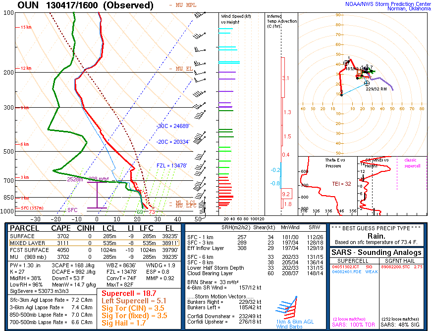
Summary: Chased with Andrew Lyons and Tyler Snider on a SW OK moderate risk. First tornado of the 2013 season, rain-wrapped cone that went through Lawton and did minor damage. Chased several HP supercells across SW Oklahoma but missed the best tornado coming from tail-end charlie near Vernon, Texas as the dryline shifted east in the mid-late evening. Overall a frustrating day that did not live up to the hype but I was still able to pull out some good shots of the tornadic HP near Lawton.
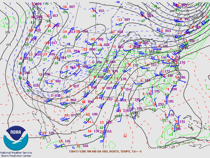
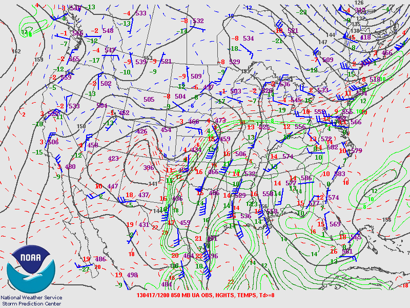
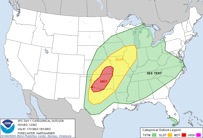
The long-range models picked up on this day pretty quickly, roughly 180 hours out. The GFS was throwing around doomsday outbreak scenarios, with the front lifting north to almost the I-70 corridor, with the dryline setting off storms in a volatile environment with CAPE values sitting at 5000 j/kg+ and deep layer shear aoa 50 kts. The Euro on the other hand took a far more conservative outlook on it, with the front lifting to about Woodward and remaining draped across northern Oklahoma until nightfall, with the triple point intersection of the dryline and the front being the focal point for development. This model uncertainty plagued the setup from the beginning and became more muddled when the NAM, WRF and SREF entered the fray. The NAM had a much more progressive front come crashing through around 00Z, potentially killing storms before the show could really get started. Unfortunately, the NAM ended up being correct, and it nailed the front position the day of exactly. The SPC threw out a MDT risk for most of central and eastern Oklahoma with a 15% hatched tornado risk.

While winds the morning of looked spectacular, the positively tilted trough and distinct veering in the 700-850mb layer would ultimately end up preventing this day from realizing its potential. Still, morning soundings looked impressive and SW Oklahoma looked primed for development as the stratus deck cleared further south ahead of the front.
We got a late start to the day, not leaving until about 3:30 CDT but this ended up working out perfectly. Storms that were already ongoing near Frederick slowly got their act together and as we were within 25 minutes of Lawton, the first supercell went tornado warned. We got off at Elgin and turned south so we could meet up with another group and wait for the storm to come to us. We stopped at a gas station and observed the storm for awhile as it moved into Lawton. We also found a kitten that took to following us around the entire time we were there. The little guy even tried to get into the car when we went to leave.


Shortly after the second photo we decided to reposition to southwest of Lawton to catch the next storm bringing up the rear. The updraft continued to look healthy until we got off on SR 36 southwest of Lawton. The storm had begun to look outflow dominant, although still had a cool HP look to it with a slight green tint back in the core.


Shortly after the last photo, a radar update piqued our interest. At the time the storm was pulling in absolutely insane inflow and a couplet began to show up on radar. The tornado warning popped up right after and we bolted back to the cars and tried to get back east and north. We ran into the TWC crew on the way (they have a rather large convoy) and got a nice view of the storm on SW 82nd Street as it began to creep into Lawton. We noted a funnel down the road a ways and as it moved into Lawton saw two power flashes, one illuminating what looked like a cone funnel above it.


Even without the tornado fully visible, I decided to count this one as the first of 2013 considering we did get a brief glimpse of it, even if it wasn't what I had been hoping for. We let the supercell pass due to limited road options that would not require us to go driving through a potentially rain-wrapped updraft region and instead tried our luck on the second storm right behind it. While it looked promising for awhile, the storm got undercut and quickly died. After that we decided not to go down to the Red River after the tail-end charlie that had popped up (big mistake) and began making our way back towards Norman.


We cut north on US 81 shortly after learning about a tornado that was in progress near Elgin (right where we had been earlier) and opted to stop in Marlow and let the hail core/supercell pass, with tennis balls being reported up the road between Marlow and Rush Springs. We made it back to Norman around 10 PM and noted some flooding on Lindsey Street on the way, with one woman's car stalled out with water above her knees.
All in all, it was not what I had been expecting at all with the high promise this day had, but the lack of dryline interaction except down in Texas coupled with the rapid southward turn of the cold front by 00Z ruined this day. While I'm disappointed, it is still cool to finally get my first tornado of the 2013 season, even if it was a rain-wrapped bird fart. Hopefully 2013 kicks it into gear sometime soon!
Chase Stats
Miles Driven: 221.2
Cost: $15
Tornadoes: 1
Hail: None
Winds: 55+ (inflow)
Season Update
Well I technically got my first tornado of the season on Wednesday. Caught the second storm that went through Lawton and got a brief view of a cone funnel followed by a few power flashes on the west side of the city. I have two chase logs to get up in the next week or two so be on the lookout.

Right now its looking like the season will remain quiet through much of the final week of April. The Euro and GFS have been throwing out possible strong return flow in the next week and a half, but I'm not setting much stock in that solution until I can see it three days out. Currently we're sitting at roughly 194 total tornado reports. Most of these are centered in Dixie Alley, with a total of 17 tornadoes in the traditional alley. Another startling stat is there were 84 tornadoes in January versus 43 currently in April. While this could be deceptive and may end up leading to a much later June season on the northern Plains and Midwest/Great Lakes region, it's still troublesome looking at how quiet of a year its a been. Very few people have scored photogenic, fully-condensed tornadoes. The best tornado as of yet has been the the surprise Caprock tornado on April 1st that a very select few chasers nabbed. Overall, not very encouraging in the greater scheme of things.

Right now its looking like the season will remain quiet through much of the final week of April. The Euro and GFS have been throwing out possible strong return flow in the next week and a half, but I'm not setting much stock in that solution until I can see it three days out. Currently we're sitting at roughly 194 total tornado reports. Most of these are centered in Dixie Alley, with a total of 17 tornadoes in the traditional alley. Another startling stat is there were 84 tornadoes in January versus 43 currently in April. While this could be deceptive and may end up leading to a much later June season on the northern Plains and Midwest/Great Lakes region, it's still troublesome looking at how quiet of a year its a been. Very few people have scored photogenic, fully-condensed tornadoes. The best tornado as of yet has been the the surprise Caprock tornado on April 1st that a very select few chasers nabbed. Overall, not very encouraging in the greater scheme of things.
Friday, April 5, 2013
Chase Logs & Chase Prospects
Hey all, been awhile since I updated the blog. This upcoming early week is looking good for the southern Plains in terms of an appreciable threat for tornadic supercells across SW KS/W OK on Monday and into E OK/W AR on Tuesday. I'm also working on getting my chase log for March 9th done sometime here in the next few days so I don't get behind. Be on the lookout for more stuff soon!

Friday, March 1, 2013
Welcome to Chase Season 2013!
We have just crossed the threshold into what I consider the start of chase season 2013. While Oklahoma and the rest of the Plains remain the in the grip of winter for the near future, the ensemble from the GFS and ECMWF are hinting at a significant pattern shift that could bring more spring-like weather to the southern Plains heading into mid-March. Hopefully this occurs before I head off on spring break but either way it'll be nice to see some decent moisture return for the first time in a long time if this pans out. I'm extremely excited for the start of chase season and here's hoping we get some good setups heading into the early part of the season!
Friday, February 22, 2013
March Fast Approaching
Hard to believe there's only a mere 6 days left until March is here. We're currently sitting in a very active meridional flow regime with system after system coming off the Pacific coast roughly ever other day. While the long-range models don't show any particularly promising pattern shift for severe weather any time soon, this current pattern is excellent for helping to alleviate some of the impacts of the severe drought across the southern plains, especially in SW Kansas and W Oklahoma. This is nowhere near a drought buster pattern, considering how severe the drought still is, but some snow pack and rain every few days should help prevent some of the moisture problems setups had out here last year when the severe weather season hits its stride.
In other news, all the gear is cleaned up and "refurbished" after the marginal chase bust in the Texas panhandle earlier in February. Finally found my pack of spare batteries that were hidden deep within the confines of my dorm room last week, which could have saved me ten bucks if I had remembered where I put the damn things earlier. But I'm already looking forward to what promises to be a great season, and hopefully another early one considering my current position. I'll only be out here until the second week of May and after that I'm tied down to a job and summer classes back home for the rest of the season. Hopefully April and the first week of May come up big or I may be suffering through a bad year (looking at you 2011).
So here's to the 2013 chase season, hope it rocks.
Sunday, February 10, 2013
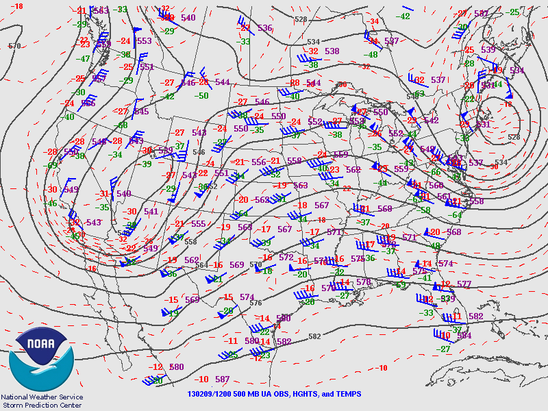
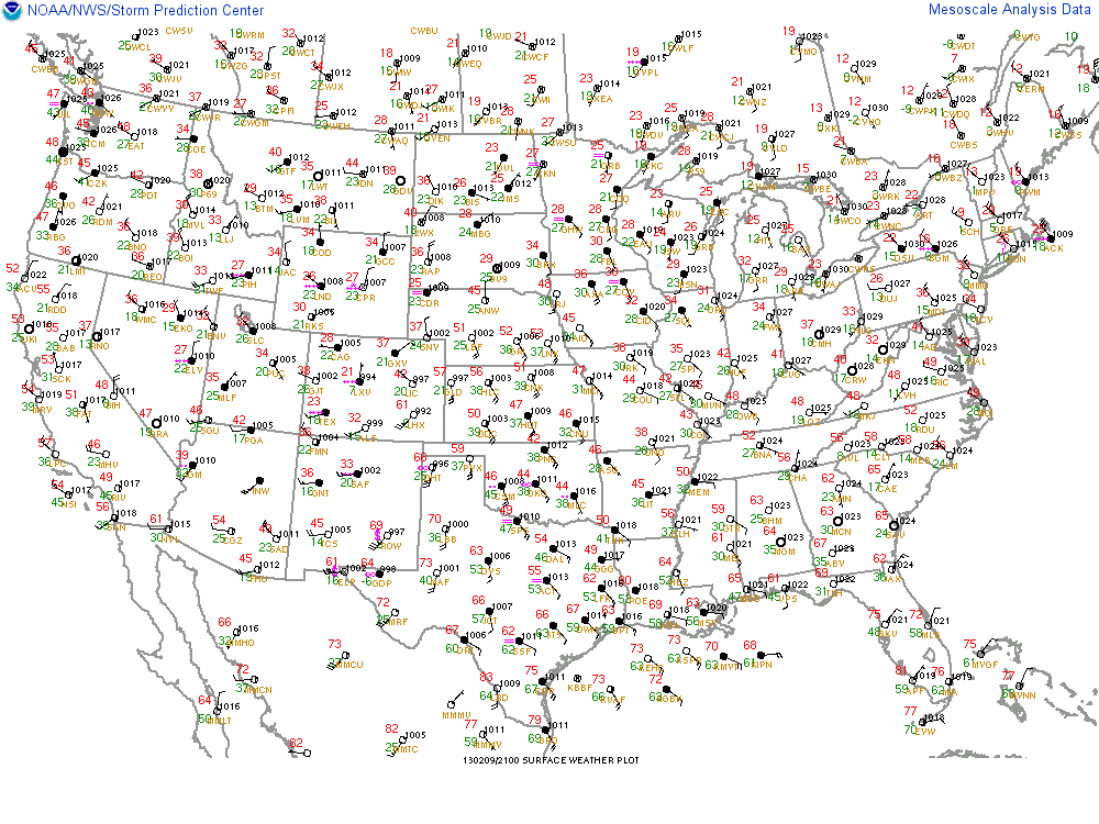
February 9 2013 Chase Log
February 9 2013
James Gustina
Summary: The opening of my 2013 chase season. Marginal day with the possibility of supercells and isolated tornadoes along the Caprock. Chased with Brady Kendrick, Jon Stone, and Zach Elliot. Targeted Childress, TX ahead of the dryline but poor moisture return plagued this setup and storms ended up going after dark. Got some large hail out of it (golf ball to tennis ball sized) as well as some fun encounters with tumbleweeds on country roads.
The GFS had picked up on this day about 300 hourss out, albeit it with significant details still question marks. A positive/neutral trough was progged to come swinging through the southern plains with an attendant 80-90 knot jet streak rounding the base of the trough some time between 18 and 21Z. Moisture was set to hit the mid-60s with a modest shear environment. The day of things had changed drastically, with the dryline setting up west of I-27 and moisture return being a serious problem on the Caprock. The shear environment still looked great with backed surface winds by 12Z with significant veering with height.


The night before I planned to chase with Brady Kendrick and Jon Stone. The tentative target was Childress where it looked like the best shear/moisture/MLCAPE would be. The morning of dews were barely hitting the lower to mid 30s in the southern panhandle.

We ended up rolling out of Norman around 11:30 that morning and after picking up Zach Elliot headed for Childress. We made a few brief stops, including at two abandoned bridges near Snyder, Oklahoma and in Hollis to check out a cool abandoned gas station.


After about twenty minutes of shooting we headed back out and ended up in Childress by 3. We grabbed lunch at Dairy Queen, something I hadn't been able to have since last July before I left for OU. We mulled over a CU field that had developed over the central panhandle just ahead of the dryline on I-27.

We decided to reposition to the north a bit as small showers popped up in the CU field. Unfortunately nothing was able to become rooted to the boundary layer and they ended up fizzling. We moved on through Memphis and then stopped a bit west of Memphis for a good while until sunset.


While we were sitting there Wesley Luginbyhl showed up and we chatted for a bit. We ended up heading back into Memphis to the Love's and grabbing some food. The general consensus was that storms would fire at some point after nightfall as the cold front and forcing caught up to the dryline. Sure enough, after about 45 minutes in Love's storms went up to our northwest near Clarendon. Unlike the earlier convection, the new storms actually got rooted and due to the favorable shear environment, got some weak mid-level rotation going. We blasted northwest towards Clarendon to get in the spot in case it decided to get its act together at the lower-levels. Unfortunately it never did but after playing chicken with it for about 15 minutes we got cored with some quarter sized stones. We hopped back on US 287 and went back towards Hedley and Memphis. At our second stop we tried again to get a view towards the updraft but the lightning was mostly cloud-to-cloud making it difficult. Shortly thereafter the bigger hail finally caught us. We estimated most of the stones were about golf ball but Brady picked up two or three dents that were at least tennis ball. After this we headed back into Hedley and then cut northeast as the storms picked back up again. Unfortunately the storms never quite got there and ended up lining out. We continued east back through Wellington and as we crossed into Oklahoma attempted to make a play on a tail-end charlie that was about to pass through Childress. That storm fizzled shortly after moving through Childress at which point we decided to call it a night. We made it back to Norman about 1 that night. Unfortunately I wasn't able to get any photos or video of the storms and the hail.
Even though the storms ended up being sub-par this was a fun way to start the season. It was still really fun to get out there again and hopefully 2013 comes out shooting when March rolls around.
Chase Stats
Miles Driven: 544
Cost: $45
Tornadoes: 0
Hail: Tennis ball (2 1/4")
Winds: None

James Gustina
Summary: The opening of my 2013 chase season. Marginal day with the possibility of supercells and isolated tornadoes along the Caprock. Chased with Brady Kendrick, Jon Stone, and Zach Elliot. Targeted Childress, TX ahead of the dryline but poor moisture return plagued this setup and storms ended up going after dark. Got some large hail out of it (golf ball to tennis ball sized) as well as some fun encounters with tumbleweeds on country roads.
The GFS had picked up on this day about 300 hourss out, albeit it with significant details still question marks. A positive/neutral trough was progged to come swinging through the southern plains with an attendant 80-90 knot jet streak rounding the base of the trough some time between 18 and 21Z. Moisture was set to hit the mid-60s with a modest shear environment. The day of things had changed drastically, with the dryline setting up west of I-27 and moisture return being a serious problem on the Caprock. The shear environment still looked great with backed surface winds by 12Z with significant veering with height.
The night before I planned to chase with Brady Kendrick and Jon Stone. The tentative target was Childress where it looked like the best shear/moisture/MLCAPE would be. The morning of dews were barely hitting the lower to mid 30s in the southern panhandle.
We ended up rolling out of Norman around 11:30 that morning and after picking up Zach Elliot headed for Childress. We made a few brief stops, including at two abandoned bridges near Snyder, Oklahoma and in Hollis to check out a cool abandoned gas station.


After about twenty minutes of shooting we headed back out and ended up in Childress by 3. We grabbed lunch at Dairy Queen, something I hadn't been able to have since last July before I left for OU. We mulled over a CU field that had developed over the central panhandle just ahead of the dryline on I-27.
We decided to reposition to the north a bit as small showers popped up in the CU field. Unfortunately nothing was able to become rooted to the boundary layer and they ended up fizzling. We moved on through Memphis and then stopped a bit west of Memphis for a good while until sunset.


While we were sitting there Wesley Luginbyhl showed up and we chatted for a bit. We ended up heading back into Memphis to the Love's and grabbing some food. The general consensus was that storms would fire at some point after nightfall as the cold front and forcing caught up to the dryline. Sure enough, after about 45 minutes in Love's storms went up to our northwest near Clarendon. Unlike the earlier convection, the new storms actually got rooted and due to the favorable shear environment, got some weak mid-level rotation going. We blasted northwest towards Clarendon to get in the spot in case it decided to get its act together at the lower-levels. Unfortunately it never did but after playing chicken with it for about 15 minutes we got cored with some quarter sized stones. We hopped back on US 287 and went back towards Hedley and Memphis. At our second stop we tried again to get a view towards the updraft but the lightning was mostly cloud-to-cloud making it difficult. Shortly thereafter the bigger hail finally caught us. We estimated most of the stones were about golf ball but Brady picked up two or three dents that were at least tennis ball. After this we headed back into Hedley and then cut northeast as the storms picked back up again. Unfortunately the storms never quite got there and ended up lining out. We continued east back through Wellington and as we crossed into Oklahoma attempted to make a play on a tail-end charlie that was about to pass through Childress. That storm fizzled shortly after moving through Childress at which point we decided to call it a night. We made it back to Norman about 1 that night. Unfortunately I wasn't able to get any photos or video of the storms and the hail.
Even though the storms ended up being sub-par this was a fun way to start the season. It was still really fun to get out there again and hopefully 2013 comes out shooting when March rolls around.
Chase Stats
Miles Driven: 544
Cost: $45
Tornadoes: 0
Hail: Tennis ball (2 1/4")
Winds: None

Subscribe to:
Posts (Atom)