Sunday, May 14, 2017

April 11 2016 Chase Log

Summary

An initially promising day with a readily-apparent OFB draped across north Texas. A supercell rode the boundary for well over an hour and almost managed to become fully surface-based but never appeared to be able to fully get ingest the boundary and get into the unstable air south of it. The storm would go on to drop some gorilla hail in Denton where we decided to stop for some good burgers at Rooster's Roadhouse.


An interesting triple point setup began to take shape roughly 2 days before this setup. A subtle impulse was progged to run right through the S. Plains. This day ended up being my first jaunt into the state of Texas for the year with Austin King, Kelton Halbert, Corey Godine and Sean Ernst.

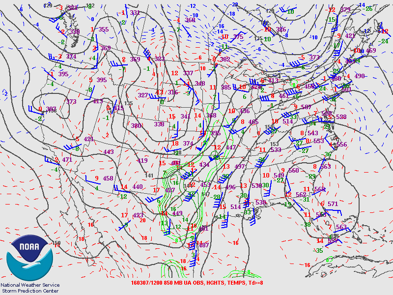
We rolled out of Norman relatively early, around 11 AM CDT to head towards north Texas where an OFB from an earlier convective complex was setting up juxtaposed with the dryline. The 18Z sounding from FWD appeared promising and we made our way down I-35 with an initial target of Nocona, TX.


Although winds appeared a bit weak, initial thoughts concluded that boundary interactions and a gradual increase/backing of sfc winds ahead of the dryline might be able to pop out a tornadic supercell.

By the time we arrived in Texas at roughly 19Z, initiation was underway at the intersection of the OFB and dryline near Archer City. We moved west along US 82 towards St Jo. At this point, it became apparent that the storm was hugging the OFB and drifting ESE. After entering St Jo, we made a run for Montague/Bowie down Texas 59. We got our first view of the storm on Texas 59 between Montague and Bowie.


The storm appeared outflowish with little indication of much low-level action in the updraft region. This continued as we traipsed southwest towards Bowie, with the storm never appearing to overtake the OFB.


We cut southeast at Bowie on US 287 as the storm began to leave us in its dust. The storm became tornado warned at this point but was still visibly suffering from being on the northern end of the OFB, with a raggedy and feature-less base. However, the steep lapse rates overspreading the dryline came into play as the storm began to show signs of some serious hail. We noted a decent amount of hail falling from the storm's RFD as we continued towards Sunset.


The terrain was generally awful along this stretch and playing catch-up didn't provide any additional photo opportunities. At Alvord, we again cut east as the storm began to maintain a more easterly course and took to the county roads near Greenwood and Slidell. We were never able to fully get in front of the storm as it headed for Denton but by this point it was a full blown hailer. We experienced golf ball sized hail with some tennis balls mixed in as we attempted to beat the storm to I-35. We entered Krum and then Denton unsuccessful and still being battered by hail. At this point, we began to give up as traveling across Denton with rush hour and large hail blocking an easy way across the town.

After letting the storm drift to the east towards worse terrain and worse roads, we settled down and decided on a place to eat. Austin, being from Denton, decided to treat us to the brisket burgers at Rooster's Roadhouse and we enjoyed a heart disease-inducing dinner before driving home to Norman.

Chase Stats
Miles Driven: 389
Cost: $25
Tornadoes: 0
Hail: Tennis ball (2.50")
Winds: ~30 mph

Friday, April 14, 2017

March 30 2016 Chase Log

Summary
A frustrating day that began with us behind from the getgo. After rushing north on I-35 and beginning to cut east to keep up with a fast moving storm that was slowly taken on supercell characteristics, we were forced to give up the chase as it entered the road dead zone of Osage County. Storms would go tornadic an hour or so later in the Tulsa areas, with a particularly strong tornado near Sand Springs.


This day initially appeared earlier in the week as a possibly potent day in central/east Central Oklahoma, with a more obvious tornado threat in the Arklatex region. By the day of a 1.5-2 km deep moist layer had overspread much of Oklahoma and Texas ahead of a dryline. The biggest issue appeared to be wind profiles providing an unfavorable environment for low-level mesocyclone maintenance owing to the poor timing and entrance angle of the trough. However, by 19Z, a weak cap had been fully eroded and CI was underway across Oklahoma and Texas.


After rolling out of Norman, we continued north on I-35 for roughly an hour until we reached Perry. Storms were already trucking along and about to pass the I-35 corridor completely. We initially latched onto a storm moving rapidly ENE as it neared Perry. We attempted to keep up for roughly 45 minutes but ended up getting left in the dust as it entered the no-man's land of Osage County where spotty roads would make it harder to keep up with the fast storm motions.

At the same time, other storms had not appeared to be getting their acts together (although the initial stages of the Sand Springs supercell were beginning on I-44) and we decided to pack it in and head back to Norman as there'd be no way we'd catch up. By the time we got back, a monstrous supercell was easily visible as it was producing the Sand Springs EF3. I managed to get my only decent picture of the day from my apartment complex's parking lot.

This day left a lot to be desired and portended the absolutely atrocious April to come but it certainly was nice to see the return of skies like this to the Great Plains.


Chase Stats
Miles Driven: 188
Cost: $5
Tornadoes: 0
Hail: None
Winds: ~30 mph

March 7 2016 Chase Log

Summary

The first chase of the year on a low-end slight risk in southwestern Oklahoma. Initially moved out of Norman for far Elk City but a surging dryline stopped us from going west of Clinton, just west of a persistent cloud deck. Surprisingly decent moisture and mediocre instability failed to combine for anything meaningful, as the dryline began to slowly mix out and retreated well before sunset with little to no cumulus ever getting going ahead of it.


This day ended up being the first shot at discrete dryline storms on the Southern Plains. We initially moved towards Clinton in the early afternoon with the intent to set up along the northern end of a dryline bulge that began to take shape just west of Mangum. After reaching Clinton, we decided to move south on US 183 to Cordell where some agitated Cu was beginning to take shape just west of a persistent cloud deck along the dryline.

Unfortunately for us, as we set up west of Cordell the Cu began to rapidly evaporate in the face of a persistent inversion and weak forcing. Roughly two hours before sunset, the dryline began to retreat, essentially signaling the end of any initiation potential. We made the short drive back to Norman, none the worse for wear.

Chase Stats 
Miles Driven: 214
Cost: $10
Tornadoes: 0
Hail: None
Winds: None


Wednesday, January 4, 2017

2015 Chase Logs Completed

Happy New Year! After much ado and a whole lot of time wasting, I finally polished off my last chase log for the 2015 season. I'll be posting a somewhat detailed 2016 chase season wrap-up before I start in on the detailed logs for this previous season, hopefully in a bit more of a timely manner so I can actually keep pace once March 2017 rolls around.


November 16 2015 Chase Log

Summary

A surprisingly potent nocturnal outbreak on the High Plains becomes the most prolific tornado event I've chased in the Texas Panhandle. After initial concerns of cloud cover and meager moisture, multiple large tornadoes traipsed across the eastern Texas Panhandle, with Pampa coming out lucky after 2 encounters with some beastly wedges.


What a day this turned out to be. This day had appeared roughly 5 days out as the last hurrah on the Great Plains for some spinning water vapor, with a rather impressive trough progged to make it's way through the Four Corners region. Initial concerns of cloud cover due to rapid moisture return over southern Great Plains and southwesterly 850s across much of the Panhandle/western Oklahoma, which is almost assuredly a death knell west of the 98 degrees, appeared more and more likely with each passing run of the GFS and Euro. The trough coming in slower also exacerbated worries about a late show or a complete no go for initiation before dark.

I was unable to leave Norman before the afternoon, but was blessedly able to bum a ride with Sean Ernst on his way out. It became incredibly clear by midday that the eastern Panhandle beyond the 10% was the place to be and we set off at a rapid clip to hopefully reach the edge of the Llano Estacado before things got good. As we got west of Shamrock and began our slow ascent, the first healthy looking storm of the day exploded to life near Tulia not long after 21Z.


We raced to get in position as it entered Palo Duro Canyon. As it began to make it's way into the canyon, it predictably took on a more beefy radar display, and the storm visually had a solid updraft with a massive, thick anvil. We jumped off I-40 at Texas 70 and quickly made our way past Howardwick, met up with some other people from OU in Clarendon and then ran west towards Goodnight on US 287.

Just east of Goodnight, we got our first good view of the base in fading light. A blocky wall cloud was emerging from the rim of the canyon and was rapidly drawing in scud.


We didn't attempt to move closer as we had found the perfect vantage point on the flat edge of the Llano. Shortly after the photo above, a thin funnel began to snake down and I watched the first tornado of the day briefly move to the southwest. Unfortunately, I had forgotten my tripod in haste to get out of Norman, making the shots I did get incredibly poor.


The tornado fizzled and shrank away as the base became more and more featureless in fading light.


We continued west after the tornado's death and entered the small community of Goodnight (named for Charles Goodnight, the scout and cattleman who partially owned the old JA Ranch which included Palo Duro Canyon). We stopped to watch the storm bringing up the rear but didn't note anything of particular interest as it casually drifted north towards Groom.


But as we continued west towards Claude we noted a suspicious lowering back in the rain that eventually became hazily visible as an ongoing tornado just north of Groom. We quickly turned heel and headed back east, attempting to use 287 to get leverage and then jump north. As most chasers already know the roads on the edge of the Llano are unforgiving, especially after dark, which hampered our ability to catch back up. After hitting one particularly bad divot, we decided to just haul it back to 40 as supercells continued to increase in number and tornadic activity.

Shortly after running east on I-40 we stopped at the edge of the Caprock near the Gray County Rest Area as a flash to our north brightened the base of the now beastly supercell running through Pampa. It illuminated the first Pampa wedge in full and we sat and watched as the tornado and parent supercell continue north and east away from Pampa. The parent storm was particularly impressive looking, with a very small to non-existent anvil but a rock solid updraft tower that was still visible with lightning and the last rays of light on the High Plains.

After watching this display we noted that there was no way we would catch up to the other tornadic supercells now rampaging across the northeastern Panhandle and decided to make our way home. All in all, a fantastic day that would have been my #1 had it occurred during the day (and maybe a bit further west back onto the Staked Plains).

Chase Stats 
Miles Driven: 530.8
Cost: $20
Tornadoes: 3
Hail: None
Highest Wind: N/A