October 4 2013
James Gustina
Summary: The marginal play on the dryline in western Oklahoma pays off huge. Chased with Andrew Lyons and Cj Sayre. Couldn't make it north to Nebraska for the tornadofest but got an amazing mothership supercell west of Clinton in the last hour before sunset. Best chase of the season for me.
This day began to show up on the long range models about a week out. All indications were that a tornado outbreak would be possible from Nebraska to Iowa. But what caught our eye was the dryline with modest instability on the order of 1500 j/kg MLCAPE along the dryline ahead of the cold front in far western Oklahoma. After debating it the night before, we finally made plans to head out to a preliminary target of Elk City around noon.
We made great time and ended up playing the waiting game at the McDonald's in Elk City for a few hours. Storms were beginning to fire back north along the cold front near Woodward and tempted as we were, we decided to stay south along the dryline. We began to move north and east when a first tower exploded directly over our heads in Elk City.
We followed this first tower north of Elk City until it began to shrivel up and die, but not before it spat out some rain and I took a little praire grass barb to the foot. I guess that's what I get for wearing sandals on a chase.
But initiation was already underway all up and down the dryline/cold front. We continued north around Foss Lake (which would prove to be a tough obstacle on a return trip) and after passing through Butler, continued east and north, which ended up giving us an amazing view of the developing storms to the west and southwest.
After the storm to our immediate west fizzled we took another look at the storm to the southwest near Sayre. It appeared to be taking on the "shape" of a storm that had unimpeded inflow and might have a shot at giving something pretty. Man were we right. We opted not to go after the garbage to the north on the cold front and after taking a lengthy detour around Foss Lake, core punched the storm and came out directly under it's base. Thankfully there was only weak rising motion as the lowest level appeared too stable and the RFD too cold for tornadogenesis. As we got out ahead of it, we were treated to an amazing view of a mothership updraft.
After the above shots, we hauled ass out of there and attempted to get as far east on I-40 as we could to get shots of the amazingly structured storm. It was weakly supercellular at best, but just west of Clinton, it gave some great photographic opportunities.
It was truly a great way to end out what had been less than a stellar season for me. After missing the final two weeks of May on a family vacation to the west, it was great to have something that was truly amazing to finish it out.
Chase Stats
Miles Driven: 290.2
Cost: $20
Tornadoes: 0
Hail: 1/4"
Wind: 40 mph (estimated in core)
Friday, January 10, 2014
September 27 2013 Chase Log
September 27 2013
James Gustina
Summary: A marginal setup with some tornadic potential in the eastern panhandle. Chased with Brady Kendrick catching some grungy crap just east of Groom as well as an awesome monster shelf just west of Alanreed. Lack of capping ruined what would have been an otherwise good day on the Caprock.
This day began showing up on the GFS several days in advance. Moisture return seemed to be a problem that would plague this setup along with almost no capping to speak of. But the day of, dewpoints in and along the Caprock canyons and along I-40 reached the mid-60s. At this, Brady and I decided to pull the trigger. Shear was modest but decent enough for a semi-discrete storm to get something going if it hit the deeper moisture pooling in the Caprock. We headed out of Norman around two, with an initial target of Groom.
We made it through the construction from hell pretty well just outside OKC and made our first stop on the other side of the state line in Shamrock at the Taco Bell. We ran into Jon there with two freshmen from OU. After shooting the breeze for awhile, we all moved west to Groom while the first storms were just beginning to take shape down by Tulia. We made it to Groom as the first storms came out of Palo Duro and became severe warned. Unfortunately, the storms had no shot at becoming even close to supercellular with the storms congealing into a line very quickly. We decided to move back east of Groom (I didn't get to see the giant cross unfortunately) and set up just off I-40 to watch the storms move in. Coincidentally enough, it was exactly where Brady had been three years earlier to watch the Groom tornado move to his south on April 22nd of 2010. We watched the storms for awhile as they puttered around and spat out some decent lightning.
In the final two photos, it briefly looked like the storm was getting it's act together and attempting to spit out a wall cloud. In the first photo below it actually had some decent rising motion but unfortunately it quickly fell apart.
We then decided to call the chase, as it was apparent that none of the storms would get isolated enough to do anything of note. As we went east on 40, the storms fully congealed into a line, with the northern segment slightly bowing out. Brady and I pulled off just past the Gray County rest area and just west of Alanreed to get some shots. We got an amazing view of a mean looking shelf rolling off the Caprock in the distance.
Brady and I continued east, briefly stopping in Shamrock for some food before continuing back to Norman. We unfortunately missed a semi-discrete storm with some monster hail that came through Shamrock not thirty minutes later, but it was after dark and a Chevy Sonic in gorilla hail is a recipe for disaster. All in all, it wasn't a bad chase and even though I thought I was ending the season, a nice reward would come exactly a week later on October 4th.
Chase Stats
Miles Driven: 468
Cost: $20
Tornadoes: 0
Hail: None encountered
Wind: 35 mph outflow
March 9 2013 Chase Log
March 9 2013
James Gustina
Summary: Chased with Jon Stone on a marginal early spring setup across southern Oklahoma and northern Texas. Caught some briefly supercellular structure with a rotating wall cloud near Payne, Oklahoma followed by a multi-tiered shelf cloud near Gainesville, Texas on an approaching multicellular line and finally some weakly supercellular storms east of Decatur, Texas. Despite the great shear environment in place over the area, storms went up in one big mess and ended up not being able to get the low-level mesocyclone organization necessary for tornadogenesis. Still, a great second chase for the season and it feels good to have gotten some severe storms for the first time since October 12.
This day popped up on the long-range GFS in the final week of February with a very different picture than the one that emerged the day of. On the morning of the 9th, a very deep longwave with a slight positive tilt was rolling out of the Rockies with an attendant jet streak rounding the base of the trough in the early morning. The initial convection that went in up in western Oklahoma along the dryline in response to that forcing would turn out to be the only storms of the day.
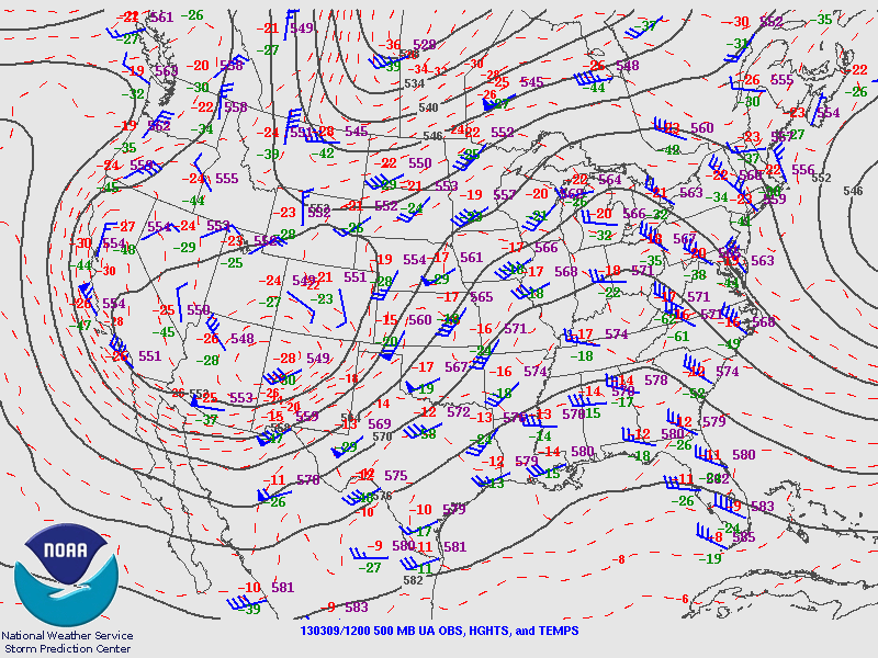
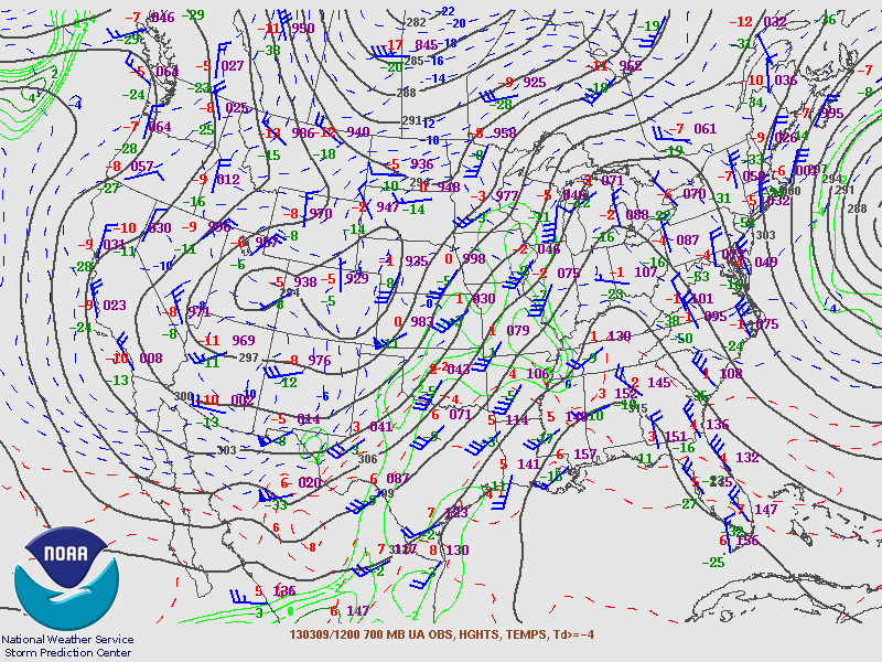
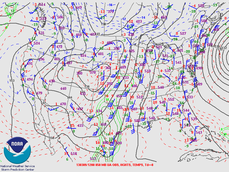

I headed out with Jon Stone around noon just as the first storms went up to the west near Altus along the dryline. From the getgo the storms were linear and outflow-ish.


We dropped south on 35 to about Paoli before cutting west on SR 19 to meet a storm that had just gone severe warned in the main line. After getting through Maysville, we cut south and then east again to get a view as the storm went northeast of us. It actually got a pretty good base going with what looked like rising motion on a lowering further up the rear-flank gust front.
We originally intended to go after it but the storm already had a decent head start and was halfway to Norman before we got back to I-35. We then decided to head south to a second line of storms that was making it's way across northern Texas. After making it across the Red River, we stopped at a rest area near Gainesville to survey a storm we had just passed through. It had a pretty awesome multi-tiered shelf with it that made for some ok photos.
After that little spectacle, we continued down the line of storms before cutting over at Valley View to view one last severe thunderstorm embedded in the line. We stopped just outside of Era and viewed a very grungy, piece of crap "shelf" if you can even call it that before calling it a day.
We then continued back north through Gainesville, with Jon trying to get some footage of the core hitting us. Afterwards, we took a brief stop to get some dinner before rolling back up to Norman.
Chase Stats
Miles Driven: 183
Cost: $35
Tornadoes: 0
Hail: none
Wind: 45 mph (estimated)
James Gustina
Summary: Chased with Jon Stone on a marginal early spring setup across southern Oklahoma and northern Texas. Caught some briefly supercellular structure with a rotating wall cloud near Payne, Oklahoma followed by a multi-tiered shelf cloud near Gainesville, Texas on an approaching multicellular line and finally some weakly supercellular storms east of Decatur, Texas. Despite the great shear environment in place over the area, storms went up in one big mess and ended up not being able to get the low-level mesocyclone organization necessary for tornadogenesis. Still, a great second chase for the season and it feels good to have gotten some severe storms for the first time since October 12.
This day popped up on the long-range GFS in the final week of February with a very different picture than the one that emerged the day of. On the morning of the 9th, a very deep longwave with a slight positive tilt was rolling out of the Rockies with an attendant jet streak rounding the base of the trough in the early morning. The initial convection that went in up in western Oklahoma along the dryline in response to that forcing would turn out to be the only storms of the day.


I headed out with Jon Stone around noon just as the first storms went up to the west near Altus along the dryline. From the getgo the storms were linear and outflow-ish.


We dropped south on 35 to about Paoli before cutting west on SR 19 to meet a storm that had just gone severe warned in the main line. After getting through Maysville, we cut south and then east again to get a view as the storm went northeast of us. It actually got a pretty good base going with what looked like rising motion on a lowering further up the rear-flank gust front.
We originally intended to go after it but the storm already had a decent head start and was halfway to Norman before we got back to I-35. We then decided to head south to a second line of storms that was making it's way across northern Texas. After making it across the Red River, we stopped at a rest area near Gainesville to survey a storm we had just passed through. It had a pretty awesome multi-tiered shelf with it that made for some ok photos.
After that little spectacle, we continued down the line of storms before cutting over at Valley View to view one last severe thunderstorm embedded in the line. We stopped just outside of Era and viewed a very grungy, piece of crap "shelf" if you can even call it that before calling it a day.
We then continued back north through Gainesville, with Jon trying to get some footage of the core hitting us. Afterwards, we took a brief stop to get some dinner before rolling back up to Norman.
Chase Stats
Miles Driven: 183
Cost: $35
Tornadoes: 0
Hail: none
Wind: 45 mph (estimated)
Subscribe to:
Posts (Atom)


.gif)


