In the face of the cold front that brought polar air from the Great White North last night, now is as good a time as any to go back and review chase season 2014. A season devoid of almost anything resembling a decent dryline day on the High Plains, the final chase ended up being my favorite.
March 15 2014 Central Texas
This day was easily the strangest chase day of the year for me. The synoptic setup was muddled, with a very weak shortwave impulse ejecting out of New Mexico the morning of and a very fuzzy dryline, with mid-50s to 60s spread from the 35 corridor to west past Abilene. The morning began socked in with thick nimbostratus as we departed Norman. After a data stop in Decatur we continued on to our target of Stephenville, Texas. A line of crapvection went up due west of us and appeared elevated and grungy. A few segments went severe warned but a second CU field was taking shape back on a sort of secondary dryline/moisture convergence zone under some decent upper-level diffluence west of Abilene. After assessing the options at the Starbucks in Comanche, SW of Stephenville (during which I nearly committed a felony against a defenseless laptop that refused to connect to wifi). After getting an outside opinion from Andrew, we decided to move west through the backroads of Texas Hill Country to make it towards the deepening Cu field. After snaking our way to just east of Abilene, we stopped in Baird for gas and continued south towards a storm taking a nice kidney bean shape that had erupted out of the Cu field just south of the first severe storm. We rapidly dropped south on US 283 and were treated to a weakly supercellular storm with some suspicious lowerings over the course of 30 minutes. We were the only chasers we saw on that road and it was dead quiet except for the occasional rustling of prairie grass from inflow and the rumble of thunder. The storm's FFD gradually pushed us south until it gusted out just north of Coleman and we let it pass. Afterwards we did some rainbow watching with Brandon Green, a panhandle chaser who I met for the first time followed by finding hailstones left behind. We ended the chase in Cisco at the Dairy Queen while watching the storm's pinkish updraft tower slowly slip into darkness before making the 6 hour drive back to Norman.


April 1 2014 Southern Oklahoma
A bust of epic proportions on the first of what was progged to be a possible three day event across the Plains. Brady Kendrick and I planned to leave Norman after I got out of class while meeting up with Zack Allen at Brady's apartment. We rolled out of Norman relatively early with a tentative target of Waurika. Very decent H5 winds, around 75 knots were overspreading Oklahoma that morning per the 12Z analysis, but the horribly veered lower levels coupled with high sfc temps leading to rapidly dropping dewpoints doomed this day out of the gates. We planned on playing the triple point as the warm front drifted lazily north of the Red River, but modest overal forcing due to the trough being a few hours to far behind ruined this target's chances. TCu struggled all day as we patiently waited at a truck stop in Waurika, the cap turning out to be nigh unbreakable. After waiting for approximately two hours with towers repeatedly toppling over in the same spot, we decided to call it quits. A storm went up further down the dryline south of Throckmorton and briefly became surface based and spat out a few lowerings. We knew there was no way we could make it that far south so we called the chase , ate at the nearby Sonic and made our way leisurely back to Norman. It should have been a red flag for what the next day held.


April 2 2014 North-Central Oklahoma
This day could have had it all. A juicy, very unstable airmass sat poised ahead of the dryline across west-central Oklahoma but failed to initiate anything of value. After debating the options, we rolled out of Norman around 5 to see if initiation would even take place thanks to the thermonuclear cap and no forcing. Storms never got going south of the warm front, with an LP supercell riding over the warm front up near Attica, KS. We sat outside Kingfisher hoping but nothing ever got close before the lack of forcing caught up to it. Such wasted potential. We would also end up not chasing the next day due to Andrew being sick and homework factors, meaning we missed the only tornadoes out of that trough.
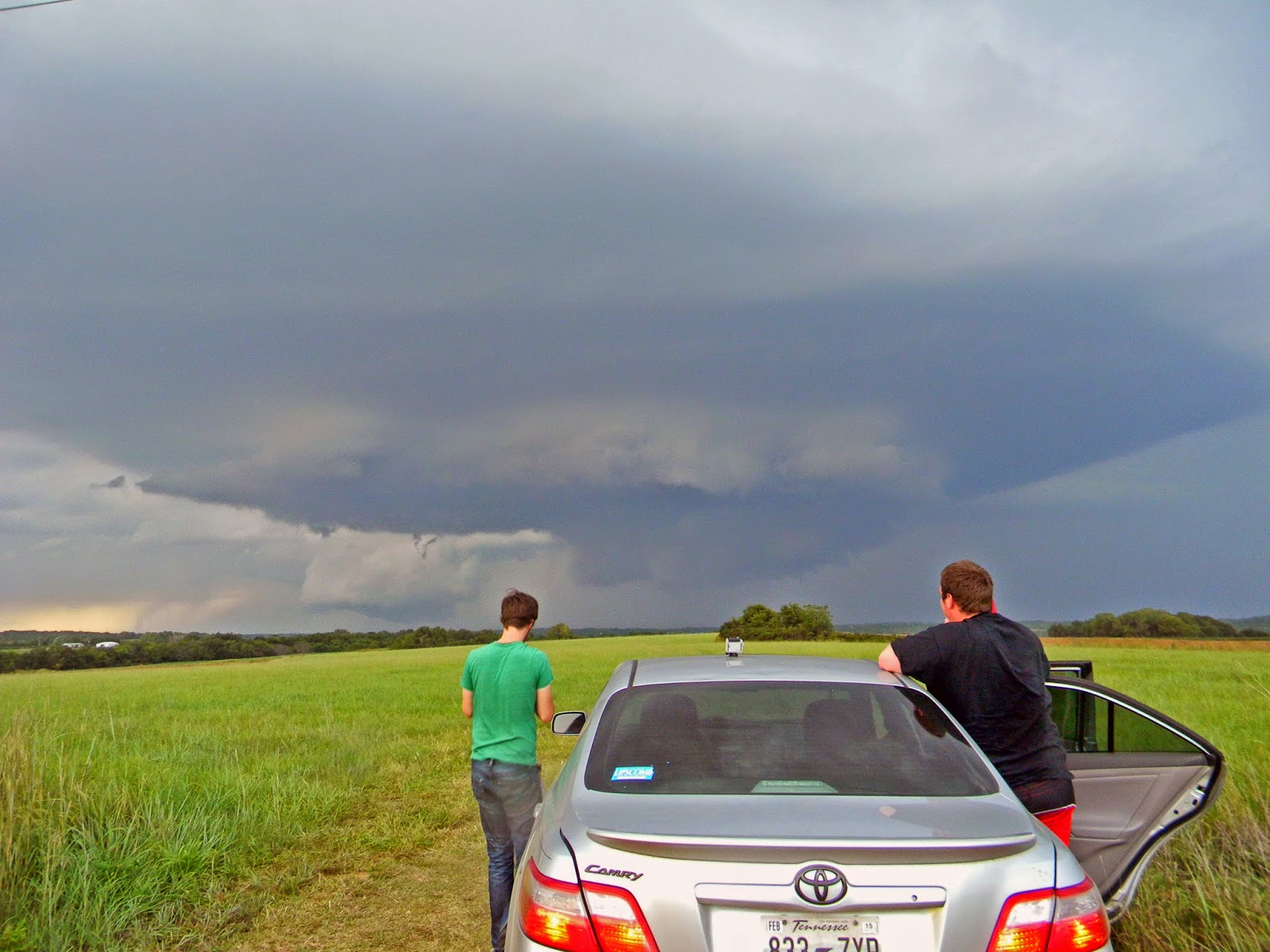
April 23 2014 Western Oklahoma & North Texas
What a strange day this ended up being. Meager moisture with a lack of appreciable capping led to a convective mess of high-based storms across the eastern High Plains. Cj and I rolled out with an initial target of Sayre, before rapidly dropping south from Erick on Oklahoma 30, watching a nice high-based supercell along the state line east of Wellington, TX. The storm rapidly gusted out and became even more elevated as we traipsed east on Oklahoma 9 towards Mangum. We were in desperate need of gas by that time, and after running through three towns with no stations and meeting up with some people from OU, we came into Mangum with a decision to make. The storms to our north and west were in a soupy mess of elevated crap and there were two storms coming out of North Texas south of Vernon. We decided on the south option and went through Duke, cut to Altus and dropped south on US 283. We stopped and watched the western storm which appeared to actually be relatively lower than the other storms in retrospect, but abandoned it west of Electra for the eastern storm. We dropped south on TX 25 from Electra and ran into the most high-based POS of the year. It had to have had a base around ~2000-2500m. It did have a nice doughnut-hole shaped base with the updraft dead center with dancing rain bands in front of the setting sun. Not what we had been hoping for this day but it had to do. We let it go after about 25 minutes and rolled into Wichita Falls for dinner at McDonald's. The real treat ended up being the insane lightning barrage from the storms on our drive back up 44. It truly was amazing to watch despite the bust.


April 26 2014 Southwest Oklahoma
Yet another bust. I had a "field trip" for my geography class to the Wichitas and after getting back at 2 PM rolled out of Norman going right back from whence I came. The moisture had initially started out in the low-60s, but as usual, it began to rapidly mix out and ended up sitting around the mid-50s. We rolled into Lawton around 3:30 and after sitting at a local park decided to go grab some food at BW3s. We anxiously watched the flat, lifeless Cu field to the WSW. Blips caught our attention but after waiting for another hour and a half, with nothing catching and the sun going down, we called it. Meager moisture and meh forcing ruined an ok shear environment. The story of 2014.
May 21 2014 Central Indiana
A chase with the local gang on what had originally looked like a possible derecho day but ended up being a messy multicell clusterfuck. Aaron Rigsby, Nathan Curtis, Andrew Lyons and I left for central Indiana and sat on a farm road south of Rushville, IN for about two hours waiting on initiation. Storm erupted quickly and a severe warned storm slowly glided towards us. After waiting on it and seeing nothing good, we began to drift west to other storms with more promise. We managed to get a pretty cool shelf with some serious greenage back in the core but that was about it. We then weaved our way through a hellhole of forested hills just east of Martinsville before getting a glimpse of a massive shelf over the hills to our NE. After getting run over, we called the chase and headed home.
July 27 2014 Eastern Ohio & Kentucky
A moderate risk day in Appalachia suckers me in. Really strong shear but meh thermodynamic profiles and fast storm motions screwed us from the getgo. Initially unsure of where to target, went north to Wilmington, OH before hauling ass south to try and get in front of the supercellular rockets before they hit the actual mountains. Missed the 60 mph moving storm by 30 minutes and sat at a DQ in Fleminsburg, KY for most of the rest of the day split by storm just north of Wilmington, one of which eventually went tornado warned and the fast moving HP monsters too far to our south to catch before sunset. On our way back to Cincinnati, elected to not chase little storm that popped in far N KY just across the river from the city. That storm ended up producing some beefy lowerings in a state park to the east and a possible tornado. 2014 strikes again.
September 1 2014 Southern Kansas
Easily, and I mean not even close, the best chase day of the year for me. We were originally not planning on chasing this day after sitting out the crapfest the day before on an overhyped, moisture starved multicell-fest in Nebraska. It wasn't until after the 17Z sounding from Lamont came out that we seriously considered going north to Blackwell. An OFB was intersecting the WF just north of the Oklahoma state line between Blackwell and Wellington. Turning in the lowest levels looked great but a massive cap was also in place. After much debating, we hit the road out of Norman around 4:45 and made it to just south of the state line just as initiation was taking place. We decided to ignore the first hints of convection along the dryline to the west in favor of the much healthier TCu ahead of us just across the state line. After a failed attempt, the next one stayed. We made it across the state line and stopped south of Geuda Springs, KS to watch the prettiest supercell of the year for us. After watching the first RFD surge fail to spawn a tornado, we dropped back south and then east to Arkansas City. We made a serious mistake in going south and were forced to double-time back to a dirt road that was literally right on the state line. We watched the now mothership sup spin and occlude twice before attempting to go east but being forced back due to a wash out and shit road options in Osage county. We ended up missing the two tornadoes at dusk near Cedar Vale but that's just how it goes. We stopped briefly near Mullhall, OK to grab some crawlers before headed home. At least the season ended on a high note.