The grandaddy of the 2015 season for me. Another day where heavy precipitation lopped off the northern target along the dryline, with the southern end of the target becoming southwest Oklahoma along the river. After setting up shop in Childress, noted that storms were generally elevated and we continued to wait on a storm to establish itself. Shortly after repositioning to the east of town, two cells congealed near Paducah and began to work their way northeast. Eventually, the storm became supercellular as it neared US 287 before producing a large wedge tornado southwest of Elmer, OK near the US 283 Red River crossing. The tornado lasted for some time and we managed to keep a decent distance, but not enough to avoid losing the windshield to inflow-driven baseballs. The storm rapidly went HP throughout the tornado's life cycle and we eventually dropped the storm and finished with wings in Lawton.


This day popped up on the radar roughly three days in advance, with generally poor consistency between the models. The NAM continued the trend of under-forecasting shear with the GFS (somewhat correctly) shooting low on progged CAPE values in the warm sector. The general consensus was that morning precip would likely be a problem regardless of the model solution and it would come to fruition that morning, as elevated storms and clouds socked in the northern end of the target area. This effectively removed a western Kansas target that had been tossed around for the likely better shear that would be present because of proximity to the main impulse.
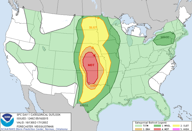
However, the SPC maintained a large moderate across the southern Plains, with a large 15% hatched tornado risk present on the 13Z outlook.

This would be amended in later outlooks to essentially encompass western Oklahoma but it was clear that the possibility for several tornadoes was there. As we rolled out of Norman, we decided on an initial target of Cordell. We arrived in Cordell shortly after 11 but decided to continue trekking further south as it became apparent the better clearing was shaping up along the Red River. As we entered Hollis, storms began to fire in the Texas Panhandle. The initial storms looked extremely messy and we decided against moving on the storm near Wellington which would produce a rain-wrapped tornado that some chasers managed to peek through the rain at.

The storms in and around Childress continued to look anemic and we pondered our options. Storms were beginning to fire to our south/southwest near Paducah and we had few other options at the time so we began to drift east towards Quanah. We mucked about on dirt roads south of Quanah as the storm rapidly got it's act together and became severe warned at roughly 2140Z. We booked it east to Chillicothe before turning north on a series of farm market roads and got our first solid view of the storm's base, which was beefing up as dusty inflow came howling in.

We continue northeast towards US 283 to get to our river crossing and hopefully beat the storm. 20 minutes after the photo above, the storm went tornado warning with a tight low-level circulation as it crossed over the Red River. Our view of the base was obscured by the RFD as we crossed the river.

The tornado was ongoing as we crossed the river, and made a slight jaunt back into Texas, before moving south of Elmer. With a hazy view behind us, we didn't get the full view until the tornado was roughly 1.5-2 miles off and were surprised when the barrel-shaped funnel emerged.

We stopped briefly outside a farm house north of Elmer as the tornado closed in on US 283 before quickly bailing north towards our east option (OK-5). On the way, we encountered extremely strong inflow accompanied by wind-driven hail up to the size of baseballs. The windshield did not survive after a baseball scooted across the hood and hit the bottom right corner, with cracks spider-webbing to the top. We hauled it on OK-5 and stopped to view the wedge back to our southwest.


We continued east and decided to stop outside Tipton and ran into a few friends. We watched as the tornado transitioned into a stovepipe, partially concealed by rain as the supercell became more HP.

After the photo above, we continued through Tipton as the conga line of chasers snaked their way down OK-5. We never felt comfortable enough to try and hop back in front of the updraft region of the storm as the storm began to approach the Wichita Mountains. After pushing through Snyder, we cut east towards Cache in search of gas out of the way of the supercell. We briefly stopped in Cache which allowed me to grab the last photo below of the twisting updraft tower to the north.

We decided to call the chase at the gas station as the windshield was becoming unstable and scurried into Lawton to the BW3s before the rain arrived. The tornado drought that had been ongoing since 2013 finally ended.
Chase Stats
Miles Driven: 451.4
Cost: $32
Tornadoes: 1
Hail: 2.75"
Wind: 65 mph