March 2, 2012 Chase
Log
James Gustina
Summary: March 2nd
ended up being my second chase of the season and the first chase I
had with a tornado. Storm speeds were ridiculous (70 mph) and with
the storms being HP coupled with the hilly terrain in and around the
Ohio River in Kentucky made this day extremely difficult to chase.
Lucked out on the second supercell and caught a brief rope as it
condensed on the other side of the road and did some low-end EF2
damage down the road.
March 2nd
stood out very early on the GFS runs in the last week of February.
The accuracy of the runs leading up to March 2nd were
astounding. The GFS had a significant storm system affecting the Ohio
Valley sometime between March 2nd-March 3rd.
Excellent moisture return, with dewpoints in the lower 60s as far
north as Indianapolis along with an extremely sheared environment
made this day worth looking at in its own right. But the biggest
shock was the projected instability values. The NAM was showing
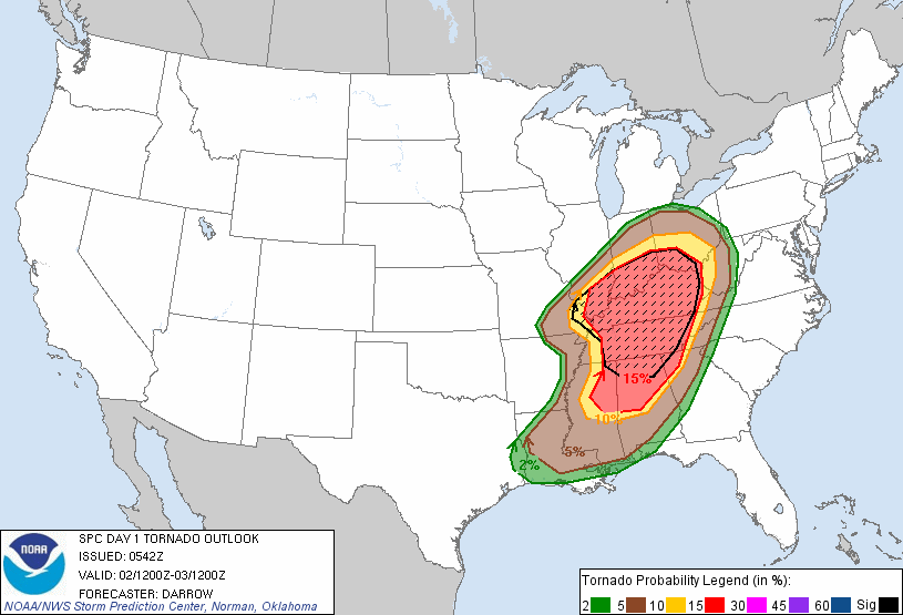
MLCAPE in excess of 2000 j/kg. The SPC ended up going with a moderate
risk at 6Z with a significant tornado threat (15% hatched) over most
of Kentucky, extreme southern Indiana and Ohio, as well as central
Tennessee. They would later upgrade it to a high risk with a 30% hatched tornado risk over all of Kentucky and southern Ohio.


I made arrangements
to go out right after school and ended up rolling out of Cincinnati
around 3:00 as two supercells were moving across southern Indiana,
the lead cell producing the Henryville tornado.


The storms were
moving exceptionally fast so we made the choice to hop on I-71S. That
was perhaps the biggest mistake of the chase. We were about two miles
outside of Glencoe, Kentucky with the lead supercell above crossing
the river headed directly for our stretch of interstate. Traffic had
slowed to a crawl due to an overturned semi in the median ahead. With
the lead supercell crossing the river we finally made it through the
bottleneck and exited at Glencoe. We drove south for about a mile and
tried to get a view of the base but the hills ended up blocking our
view. We were forced to drop that cell since there were no viable
road options at the time. We continued to drop south on US 127 as the
second supercell came across the river. We got our view of the base
about 5 miles south of Glencoe and stopped. We had come into the
notch from the north so we had a pretty good view of the rain-wrap
around the backside. We waited and let the gust front pass over.


After the gust front
passed Ryan noted rapid motion right down the road. A nubby funnel
poked out of the wall cloud and we observed a dust cloud under it.
Within about 15 seconds the tornado almost fully condensed and
rapidly moved off to the east. The RFD hit us within a minute with
ping-pong ball sized hail and roughly 60 mph winds.


We got blasted with
rain and hail for about two more minutes before we finally continued
south. There had been a power flash down the road but we hadn't
noticed any debris at the time. Unfortunately the tornado hit a
stable, ripping the roof off and collapsing some of the walls, as
well as a house which lost a part of its roof.
Thankfully no one
was badly injured.

We stayed for about 30 minutes after the tornado
waiting for the local police and fire show up. At that point we were
unsure of continuing the chase due to the time of day (darkness was
only about an hour and a half away at this point) and how far away
all the remaining storms were. We moved out and continued south to
Frankfort before calling the chase. We came back through the area
that had been hit earlier and the police had completely blocked it
off. I haven't heard anything about rebuilding but hopefully the
owners were able to rebuild. The National Weather Service in
Wilmington rated the tornado as a low-end EF2. It stayed on the
ground for about 5 miles with a maximum width of 150 yards.
Chase
Stats
Miles Driven: 174
Chase costs: $80
Tornadoes: 1 (EF2)
Max Hail Size: ping pong
Miles Driven: 174
Chase costs: $80
Tornadoes: 1 (EF2)
Max Hail Size: ping pong
No comments:
Post a Comment