Summary
May 25 was my favorite chase of the season. The day had some huge question marks going into the morning of, mainly the strength of the cap and how far the dryline would actually advance. The morning of though, everything looked perfect. I ended up with two tornadoes and some amazing classic structure on the first storm of the day south of Russell, Kansas. All in all, a great day.
This day started out as a sleeper setup on the NAM. A nice shortwave was progged to come screaming out of the Rockies the morning of. High instability would be a given due to the sfc temps well into the hundreds with dewpoints well into the upper 60s. The shear profiles right at the triple point looked good for at least a few tornadoes on the NAM with 90 degree turning in the lowest layer, but there was a cap stronger than Fort Knox at 850 mb that kept showing up every run. Thankfully the NAM was wrong about the cap.
We woke up in Des Moines that morning and over a very early breakfast we looked at the 12Z soundings and surface charts. There was definitely an inversion, but with the surface heating that was going to occur later combined with the shortwave it would no doubt break. But the most pleasing were the shear profiles. Deep layer shear of 59 knots with SFC-1 km helicity at 550 m^2/s^2.

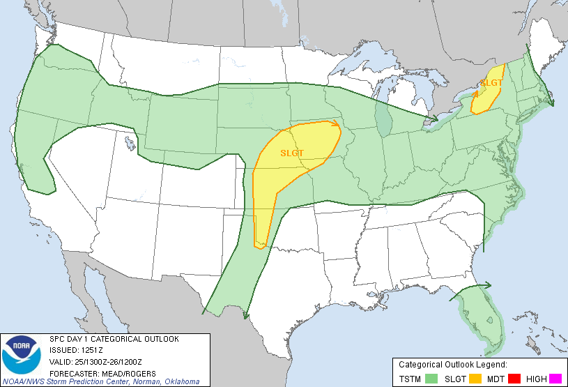
Though the warm front was still along the OK/KS line, it looked like it would rapidly lift to around the I-70 corridor in the late afternoon/early evening. We rolled out of Des Moines around 9 and headed for Kansas City. Our tentative stopping point would be Salina to figure out where to go next. Since I had forgotten the air card like a dunce back in Cincinnati, Andrew Lyons nowcasted and sent satellite images as well as mesoanalysis charts. We stopped in Kansas City for some barbeque around noon before heading for Salina. By 18Z things were looking excellent in west-central Kansas. The dryline was advancing east and was just east of Dodge City with the warm front draped a few counties south of I-70.
Around 3 (19Z) we stopped in Salina to get data. We sat in Salina for about 50 minutes deciding where to go from here when the SPC issued the first MCD of the day in Kansas. With the triple point looking like the best bet, we continued west on 70 and cut down to Great Bend. Just as we were entering Great Bend, the first storm of the day went up. After a slight detour in Great Bend (someone who shall remain nameless had to use the facilities of a Pizza Hut), we were headed back north paralleling the cell on US 281.


Shortly after this more storms went up along the dryline. This storm started out LP and began the usual transition towards a more classic type. We got our first full view of the base shortly after the last photo above was taken. It had a nice wall cloud early on and began to organize more as it moved closer and closer to the warm front.


We sat on this dirt road for awhile watching the storm slowly mature with more towers going up. It was amazing to watch the towers rise in a row and begin to anvil out as the cell in front of us started beefing up.


Shortly after we drifted north to keep pace with the storm. It's updraft base beefed up considerably with a nice wall cloud. After we found another nice dirt road to turn off onto, the RFD began to cut in around the back. It was during this phase that we saw what might have been a "possible" tornado under the wall cloud but we weren't sure since there was no discernible funnel from our position.


We continued to watch that backside but nothing similar happened again. The RFD began to shred the back side of the wall cloud and the storm slowly morphed into a beautifully structured classic supercell.


We ended up missing some the last tornado near Russell but all in all it was the best day of the season. We headed back up to Hays and after downing some Sonic, got onto I70 to head back east to Topeka for the night.
Chase Stats
Miles Driven: 563 miles
Cost: $200
Tornadoes: 3
Hail: none
No comments:
Post a Comment